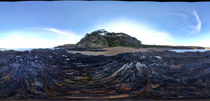
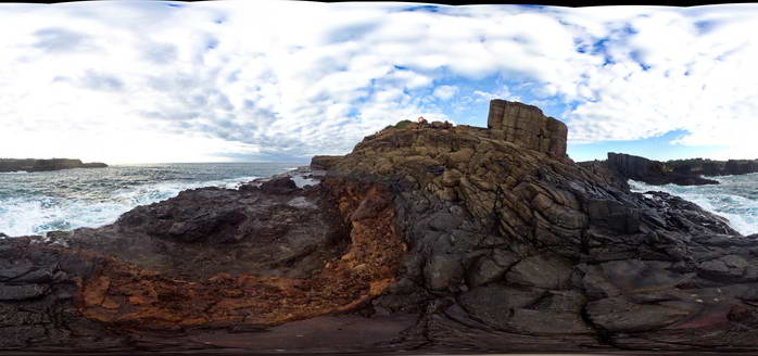
Canberra1 Map
 |
5 |
06/20/2016 3:47 p.m. |
3D |
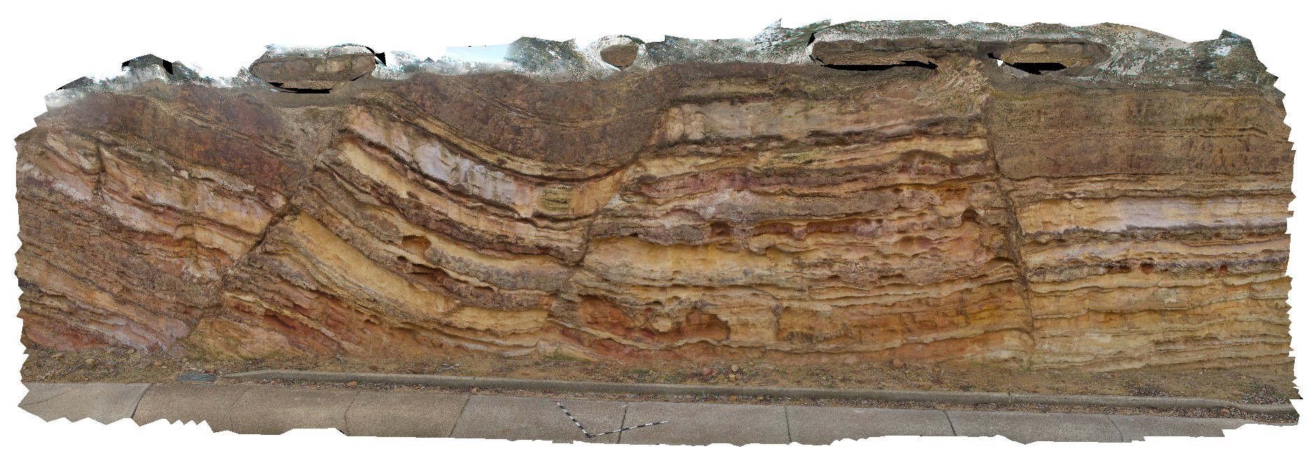
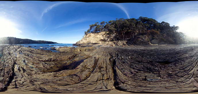
Open folds and faults in Silurian sandstone and mudstone at the Sate Circle in Canberra, A.C.T. |
10.00 |
-35.30408000000 |
149.12651000000 |
580.000 |
folds, faults, structure |
sandstone |
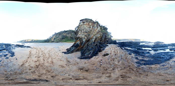
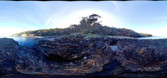
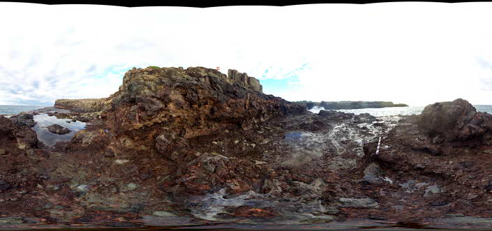
CanberraFSP1 Map
 |
5 |
06/17/2015 10:22 a.m. |
FSP |
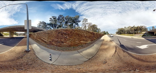
Open folds and faults in Silurian sandstone and mudstone of the Camp Hill Sandstone. A.C.T. |
50.00 |
-35.30497000000 |
149.12817000000 |
580.000 |
folds, faults, structure |
sandstone |
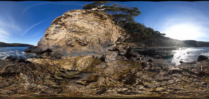
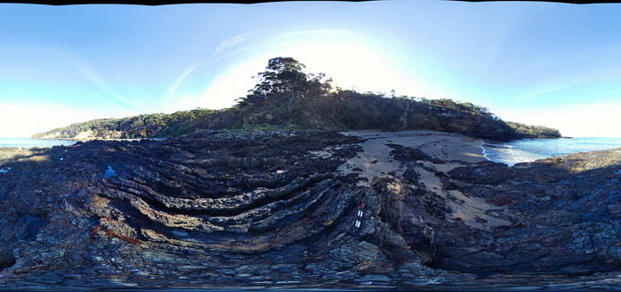
MyrtleBchFSP4 Map
 |
5 |
06/17/2015 9:47 a.m. |
FSP |
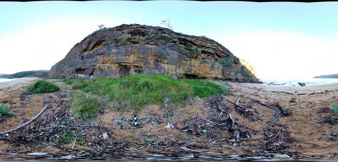
Cliff of Basal Permian Snapper Point Formation sandstone with megabreccia blocks (to ~6m) of folded Lachlan Orogen metasediments. Myrtle Beach, N.S.W. |
50.00 |
-35.68269000000 |
150.30042000000 |
1.000 |
megabreccia, sedimentology |
sandstone |
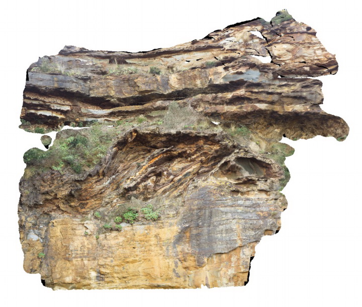
MyrtleBchFSP3 Map
 |
5 |
06/17/2015 9:46 a.m. |
FSP |
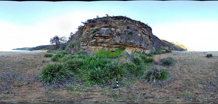
Basal Permian unconformity with steeply dipping metasediments of the Cambro-Silurian Wagonga Group overlain by flat-lying Permian sandstone and breccia of the Snapper Point Formation. Myrtle Beach, N.S.W. |
50.00 |
-35.68272000000 |
150.29979000000 |
1.000 |
unconformity, structure |
mudstone, sandstone |
MyrtleBchFSP3 Map
|
5 |
06/17/2015 9:46 a.m. |
FSP |
Basal Permian unconformity with steeply dipping metasediments of the Cambro-Silurian Wagonga Group overlain by flat-lying Permian sandstone and breccia of the Snapper Point Formation. Myrtle Beach, N.S.W. |
50.00 |
-35.68272000000 |
150.29979000000 |
1.000 |
unconformity, structure |
mudstone, sandstone |
MyrtleBchFSP2 Map
 |
5 |
06/17/2015 9:45 a.m. |
FSP |
View of folded and faulted thinly bedded fine grained metasediments of the Cambro-Silurian Wagonga Group. Flat lying basal outcrops of the Sydney Basin are visible at the end of the beach to the north. Myrtle Beach, N.S.W. |
50.00 |
-35.68432000000 |
150.29828000000 |
0.000 |
folds, structure |
mudstone |
MyrtleBchFSP1 Map
 |
5 |
06/17/2015 9:44 a.m. |
FSP |
View of folded Cambro-Silurian metasediments of the Wagonga Group. Myrtle Beach, N.S.W. |
50.00 |
-35.68479000000 |
150.29781000000 |
0.000 |
folds, structure |
mudstone |
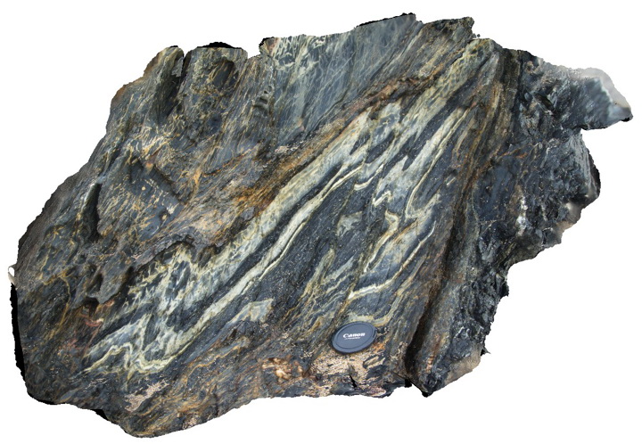
MyrtleBch4 Map
 |
5 |
06/17/2015 9:42 a.m. |
3D |
detail of folds and faults in fine grained metasediments of the Cambro-Silurian Wagonga Group. Myrtle Beach, N.S.W. |
1.00 |
-35.68481000000 |
150.29784000000 |
1.000 |
folds, faults, structure |
mudstone |
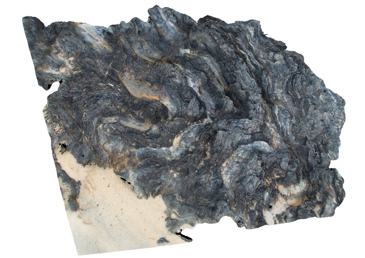
MyrtleBch3 Map
 |
5 |
06/17/2015 9:30 a.m. |
3D |
folds developed in fine grained metasediments of the Cambro-Silurian Wagonga Group. Myrtle Beach, N.S.W. |
2.00 |
-35.68435000000 |
150.29822000000 |
0.000 |
folds, structure |
siltstone |
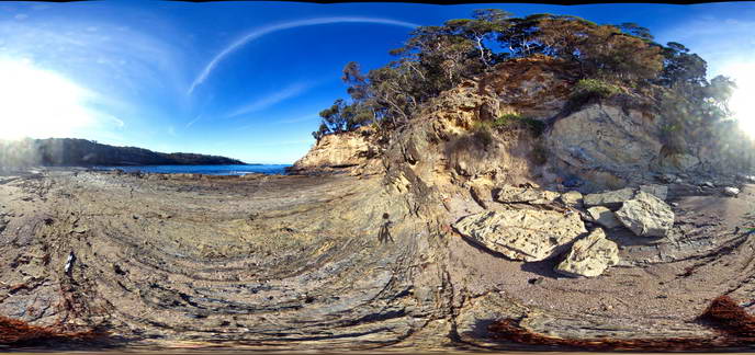
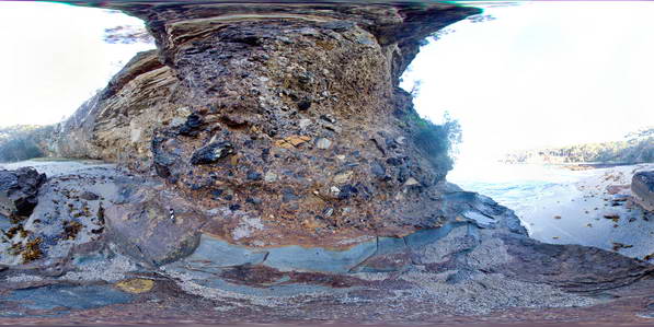
MyrtleBch2 Map
 |
1 |
06/17/2015 9:23 a.m. |
3D |
Large (~6m) megaclast of folded Wagonga Group rocks within cliff of Permian Snapper Point Formation. Poor image due to limited vantage points. No scale. Myrtle Beach, N.S.W. |
0.00 |
-35.68269000000 |
150.30045800000 |
-9999.000 |
megaclast, sedimentology |
sandstone |
MyrtleBch1 Map
 |
5 |
06/17/2015 9:19 a.m. |
3D |
Basal Permian unconformity with steeply dipping silty sandstone of the Cambro-Silurian Wagonga Formation overlain by sandstone with large erratic clasts of the Permian Snapper Point Formation. Myrtle Beach, N.S.W. |
8.00 |
-35.68271000000 |
150.29996000000 |
2.000 |
unconformity, structure |
sandstone, sandstone |
MyrtleBch1 Map
|
5 |
06/17/2015 9:19 a.m. |
3D |
Basal Permian unconformity with steeply dipping silty sandstone of the Cambro-Silurian Wagonga Formation overlain by sandstone with large erratic clasts of the Permian Snapper Point Formation. Myrtle Beach, N.S.W. |
8.00 |
-35.68271000000 |
150.29996000000 |
2.000 |
unconformity, structure |
sandstone, sandstone |
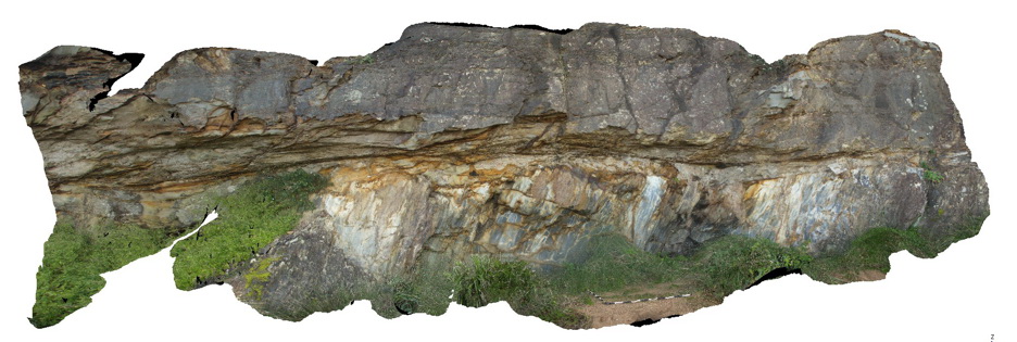
DarkBchFSP6 Map
 |
5 |
08/27/2015 2:20 p.m. |
FSP |
Exposed unconformity between steeply dipping metasediments of the Cambro-Silurian Wagonga Group with flat-lying sandstone and breccia of the Permian Snapper Point Formation. Dark Beach, N.S.W. |
50.00 |
-35.67953000000 |
150.30003000000 |
0.000 |
unconformity, structure, sedimentology |
sandstone, breccia |
DarkBchFSP6 Map
|
5 |
08/27/2015 2:20 p.m. |
FSP |
Exposed unconformity between steeply dipping metasediments of the Cambro-Silurian Wagonga Group with flat-lying sandstone and breccia of the Permian Snapper Point Formation. Dark Beach, N.S.W. |
50.00 |
-35.67953000000 |
150.30003000000 |
0.000 |
unconformity, structure, sedimentology |
sandstone, breccia |
DarkBchFSP5 Map
 |
5 |
08/27/2015 2:20 p.m. |
FSP |
View of steeply dipping metasediments of the Cambro-Silurian Wagonga Group with flat-lying sandstone and breccia of the Permian Snapper Point Formation in the background. Dark Beach, N.S.W. |
50.00 |
-35.67946000000 |
150.29959900000 |
1.000 |
unconformity, structure, sedimentology |
sandstone, breccia |
DarkBchFSP5 Map
|
5 |
08/27/2015 2:20 p.m. |
FSP |
View of steeply dipping metasediments of the Cambro-Silurian Wagonga Group with flat-lying sandstone and breccia of the Permian Snapper Point Formation in the background. Dark Beach, N.S.W. |
50.00 |
-35.67946000000 |
150.29959900000 |
1.000 |
unconformity, structure, sedimentology |
sandstone, breccia |
DarkBchFSP4 Map
 |
5 |
08/27/2015 2:20 p.m. |
FSP |
View of steeply dipping metasediments of the Cambro-Silurian Wagonga Group with flat-lying sandstone and breccia of the Permian Snapper Point Formation in the background. Dark Beach, N.S.W. |
50.00 |
-35.67945000000 |
150.29971000000 |
0.000 |
unconformity, structure, sedimentology |
sandstone, breccia |
DarkBchFSP4 Map
|
5 |
08/27/2015 2:20 p.m. |
FSP |
View of steeply dipping metasediments of the Cambro-Silurian Wagonga Group with flat-lying sandstone and breccia of the Permian Snapper Point Formation in the background. Dark Beach, N.S.W. |
50.00 |
-35.67945000000 |
150.29971000000 |
0.000 |
unconformity, structure, sedimentology |
sandstone, breccia |
DarkBchFSP3 Map
 |
5 |
08/27/2015 2:20 p.m. |
FSP |
View of steeply dipping metasediments of the Cambro-Silurian Wagonga Group with flat-lying sandstone and breccia of the Permian Snapper Point Formation in the background. Unconformity is obscured by grass and talus. Dark Beach, N.S.W. |
50.00 |
-35.67817000000 |
150.30003000000 |
1.000 |
unconformity, sedimentology, structure |
breccia, sandstone |
DarkBchFSP3 Map
|
5 |
08/27/2015 2:20 p.m. |
FSP |
View of steeply dipping metasediments of the Cambro-Silurian Wagonga Group with flat-lying sandstone and breccia of the Permian Snapper Point Formation in the background. Unconformity is obscured by grass and talus. Dark Beach, N.S.W. |
50.00 |
-35.67817000000 |
150.30003000000 |
1.000 |
unconformity, sedimentology, structure |
breccia, sandstone |
DarkBchFSP2 Map
 |
5 |
08/27/2015 2:20 p.m. |
FSP |
View of steeply dipping metasediments of the Cambro-Silurian Wagonga Group with flat-lying sandstone and breccia of the Permian Snapper Point Formation in the background. Unconformity is obscured by grass and talus. Dark Beach, N.S.W. |
50.00 |
-35.67807000000 |
150.30016000000 |
0.000 |
unconformity, structure, sedimentology |
breccia, sandstone |
DarkBchFSP2 Map
|
5 |
08/27/2015 2:20 p.m. |
FSP |
View of steeply dipping metasediments of the Cambro-Silurian Wagonga Group with flat-lying sandstone and breccia of the Permian Snapper Point Formation in the background. Unconformity is obscured by grass and talus. Dark Beach, N.S.W. |
50.00 |
-35.67807000000 |
150.30016000000 |
0.000 |
unconformity, structure, sedimentology |
breccia, sandstone |
DarkBchFSP1 Map
 |
5 |
08/27/2015 1:01 p.m. |
FSP |
mega breccia in Permian Snapper Point Formation immediately above the basal Permian unconformity. Poor image - very high contrast. Dark Beach, N.S.W. |
50.00 |
-35.67775000000 |
150.30070000000 |
0.000 |
mega breccia, sedimentology |
breccia |
BomboFSP5 Map
 |
5 |
08/25/2015 12:20 p.m. |
FSP |
View of the contact between the Permian Bumbo Latite and an underlying volcanic breccia. Bombo, N.S.W. |
50.00 |
-34.65197000000 |
150.86296000000 |
2.000 |
volcanology |
latite |
BomboFSP4 Map
 |
5 |
08/25/2015 12:20 p.m. |
FSP |
View of the contact between the Permian Bumbo Latite and an underlying volcanic breccia. Bombo, N.S.W. |
50.00 |
-34.65204000000 |
150.86305000000 |
1.000 |
breccia, volcanology |
latite, breccia |