Metadata

Geological Metadata

All AusGeol visualisations have geological metadata that is stored in an associated relational database. Structured metadata records provide systematic documentation of the geological characteristics of each outcrop and facilitate effective and complex database query operations.

Geological visualisations record features that may have complex attributes which cannot readily be encoded using simple 'flat' data structures. The complexity of geological attributes potentially associated with a geological visualisation is well illustrated by the conceptual outcrop below.


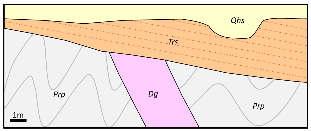
The geology of this conceptual site consists of folded Proterozoic phyllite (Prp), intruded by a dyke of Devonian biotite-hornblende granodiorite (dg), unconformably overlain by thickly bedded Triassic sandstone and siltstone containing plant fossils (Trs) and overlain by unconsolidated Holocene alluvial sediment (Qhs).

This site thus has:. 

  • Five lithologies (phyllite, granodiorite, sandstone, siltstone and alluvial sediments)

  • Rocks from four different time periods (Proterozoic, Devonian, Triassic and Quaternary)

  • Rocks from at least four different 'stratigraphic' units

  • 'Structural' features including folds and unconformities

  • Textural, mineralogical and palaeontological attributes


 In addition to these geological attributes other information about the site also needs to be recorded including:

  • Unique identifier (numeric)

  • Location (numeric)

  • Descriptive location ( free text)

  • Locational accuracy (numeric)

  • Name of the person who acquired the visualisation (coded text)

  • Date of image acquisition (date)

  • Type of visualisation (coded text)

  • Geological description of the site (free text)

To effectively encode all of these attributes requires multiple tables, linked by a range of relationships. It cannot be adequately represented using a simple flat file structure.

The AusGeol attribute database enables encoding of 'real' relationships between the attributes (eg: stratigraphy and age apply to specific lithologies, not to the entire outcrop). and diverse database queries (eg: show all visualisations that depict folds, show all visualisations that depict rocks of lower Palaeozoic age or visualisations showing basic extrusive igneous rocks). 

The basic structure of the AusGeol attribute database is illustrated below. The database has initially been developed in Microsoft Access with periodic upload of data tables to a Django database for the webpage. In the future the Django database will become the primary database which will facilitate on-line data upload and management. 


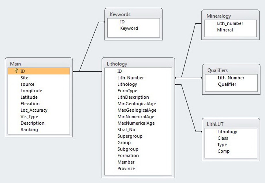
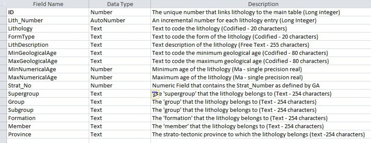
The Main table encodes the information for which there is only one possible attribute for each visualisation. The fields in the Main table are shown below.


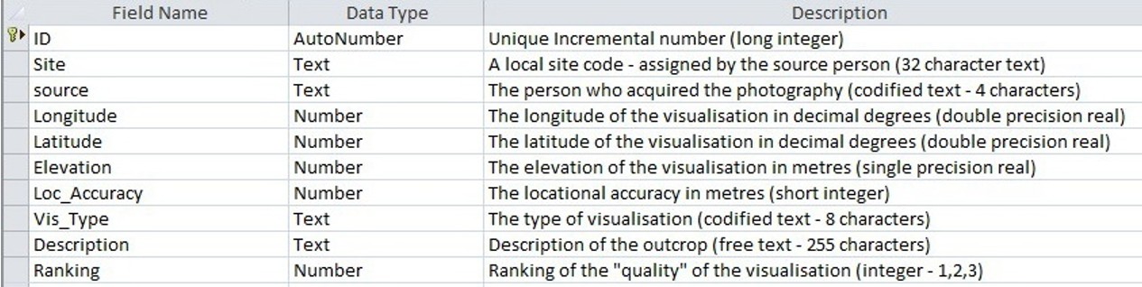
Fields in the Main table are: a unique numerical identifier (ID), a codified field identifying the person who acquired the imagery (Source), location information (Longitude,  Latitude, Elevation and Loc_Accuracy), a codified field for the type of visualisation (Vis_Type), a free text descriptive field (Description) and a numeric field that indicates the quality of the visualisation (Ranking).

Each visualisation may depict many lithologies, and information about each of these rock types is primarily encoded in the Lithology table (below).


There is a one-to-many relationship between the Main table and the Lithology table with the link between the tables based on the ID field . A unique number (Lith_Number) is assigned to each lithological entry to enable a link between lithologies and their associated detailed attributes (mineralogy and texture) that are stored in associated tables. The Lithology field is a codified field that encodes each lithology. The FormType field is a codified field that describes the form of the lithology (e.g. bed, dyke etc). LithDescription is a free text field that allows a full description of the rock type that incorporates information that cannot readily be encoded in other fields. MinGeologicalAge and MaxGeologicalAge encode the respective minimum and maximum ages in terms of standard geological age terms (e.g. Proterozoic, Permian etc). MinNumericalAge and MaxNumericalAge provide age ranges in Ma. If specific ages are known then these can be entered, otherwise these default to the ages that correspond to MinGeologicalAge and MaxGeologicalAge. Stratigraphic information is explicitly encoded in the fields Strat_No, Supergroup, Group, Subgroup, Formation and Member. 

The information in the stratigraphic fields is derived from the Australian Stratigraphic Names Database maintained by Geoscience Australia. The Province field encodes the strato-tectonic province to which the respective lithology belongs. Values for this field are also derived from the Australian Stratigraphic Names Database.

Each rock unit referenced in the Lithology table may have multiple mineralogical or textural qualifiers and this information is encoded within the Mineralogy and the Qualifiers tables. These are linked to the Lithology table via the Lith_Number field. 

The hierarchical nature of lithology is explicitly encoded in the LithLUT lookup table. The Class field specifies the rock type class (e.g. igneous, sedimentary, metamorphic and unconsolidated). The Type field provides qualifiers for the lithology class (e.g. plutonic, epiclastic, contact etc). The Comp field classifies the lithology broadly in terms of composition (e.g. basic, silicic, feldspathic etc).

Each geological visualisation may be given multiple keywords, these are stored in the Keywords table and linked to the main table by the ID field. Broad geological category keywords (eg: structure, sedimentology, palaeontology etc) are assigned to most visualisations to facilitate general category searches that might be more difficult using other database fields.

A geological metadata record is automatically generated when a visualisation is downloaded from the database. This information is downloaded with the visualisation as an ASCII text file in html format. An example of a metadata record for the Conran17 site is shown below.

Site: Conran17
Description:
Granitic dykes from the Cape Conran Granite intruding contact metamorphosed turbiditic metasediments of the Ordovician Pinnak Sandstone
Latitude: S37°48'28.15"
Longitude: E148°44'2"
Elevation: 1.0 m
Visualisation Type: 3D
Location Accuracy: +/- 5 m
Keywords:
turbidite
granite
dyke
igneous
structure
Lithology:
Granite
Form Type: dyke
Description: equicrystalline medium to coarse grained granite
Min Geological Age: Devonian
Max Geological Age: Silurian
Min Numerical Age: 394
Max Numerical Age: 417
Strat No: 3485
Supergroup:
Group:
Subgroup:
Formation: Cape Conran Granite
Member:
Province: Lachlan Orogen
turbidite
Form Type: bedded
Description: contact metamorphosed turbidite beds
Min Geological Age: Ordovician
Max Geological Age: Ordovician
Min Numerical Age: 458
Max Numerical Age: 467
Strat No: 23907
Supergroup:
Group: Adaminaby Group
Subgroup:
Formation: Pinnak Sandstone
Member:
Province: Lachlan Orogen


Copyright © 2024 AusGeol.org. All rights reserved

Site developed by Steve Harwin using Django, Mezzanine and Leaflet