AlbanyFSP6
Site:
AlbanyFSP6
Downloads:
Map
Description:
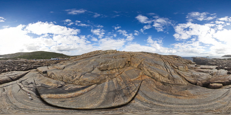
overview of the shore exposure at 'The Gap', showing granodiorite intruding banded granitic gneiss with disaggregated mafic dykes. Albany
| Capture Date: | June 5, 2016, 10:40 a.m. |
| Latitude: | -35.11838000000 degrees |
| Longitude: | 117.89299000000 degrees |
| Elevation: | NA |
| Visualisation Type: | FSP |
| Location Accuracy: | 0 metres |
Keywords:
- mafic dyke
- banded gneiss
- structure
- folding
| gneiss | |
|---|---|
| Form Type: | pluton |
| Description: | banded grey granitic gneiss with disaggregated mafic dykes. |
| Min Geological Age: | Mesoproterozoic |
| Max Geological Age: | Paleoproterozoic |
| Min Numerical Age: | 1174.000 |
| Max Numerical Age: | 1560.000 |
| Strat No: | 14258 |
| Supergroup: | |
| Group: | Nornalup Complex |
| Subgroup: | |
| Formation: | |
| Member: | |
| Province: | Albany-Fraser Orogen |
| granodiorite | |
|---|---|
| Form Type: | dyke |
| Description: | fine to medium-grained granodiorite inuring host granitic gneiss. |
| Min Geological Age: | |
| Max Geological Age: | |
| Min Numerical Age: | 0.000 |
| Max Numerical Age: | 0.000 |
| Strat No: | 0 |
| Supergroup: | |
| Group: | |
| Subgroup: | |
| Formation: | |
| Member: | |
| Province: |