Armidale7
Site:
Armidale7
Downloads:
Map
3D Model:
Description:
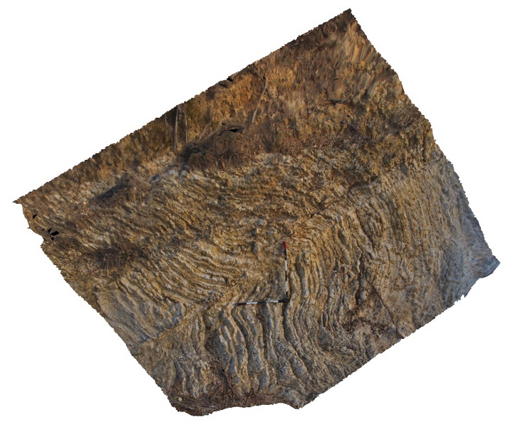
Folded and faulted thin chert and mudstone layers of the Devonian to Carboniferous Sandon Beds with overlying transported regolith. Armidale, N.S.W
| Capture Date: | July 27, 2015, 10:35 a.m. |
| Latitude: | -30.57199000000 degrees |
| Longitude: | 151.64069000000 degrees |
| Elevation: | NA |
| Visualisation Type: | 3D |
| Location Accuracy: | 5 metres |
Keywords:
- chert
- mudstone
- fold
- fault
- regolith
| chert | |
|---|---|
| Form Type: | bedded |
| Description: | thin chert layers interbedded with mudstone |
| Min Geological Age: | Carboniferous |
| Max Geological Age: | Devonian |
| Min Numerical Age: | 350.000 |
| Max Numerical Age: | 380.000 |
| Strat No: | 28301 |
| Supergroup: | |
| Group: | |
| Subgroup: | |
| Formation: | Sandon Beds |
| Member: | |
| Province: | New England Orogen |
| mudstone | |
|---|---|
| Form Type: | bedded |
| Description: | thin layers of mudstone interbedded with chert |
| Min Geological Age: | Carboniferous |
| Max Geological Age: | Devonian |
| Min Numerical Age: | 350.000 |
| Max Numerical Age: | 380.000 |
| Strat No: | 28301 |
| Supergroup: | |
| Group: | |
| Subgroup: | |
| Formation: | Sandon Beds |
| Member: | |
| Province: | New England Orogen |