CanberraFSP6
Site:
CanberraFSP6
Downloads:
Map
Description:
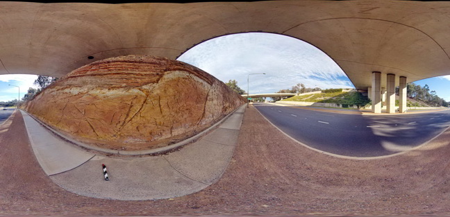
Open folds and faults in Silurian sandstone and mudstone of the Camp Hill Sandstone unconformably overlying Silurian State Circle Shale which contains disaggregated rafts of sandstone. A.C.T.
| Capture Date: | Sept. 3, 2015, 1:20 p.m. |
| Latitude: | -35.30445000000 degrees |
| Longitude: | 149.12733000000 degrees |
| Elevation: | 580.000 metres |
| Visualisation Type: | FSP |
| Location Accuracy: | 5 metres |
Keywords:
- folds
- faults
- structure
- sedimentology
| sandstone | |
|---|---|
| Form Type: | bedded |
| Description: | thinly bedded fine to medium sandstone and mudstone |
| Min Geological Age: | Silurian |
| Max Geological Age: | Silurian |
| Min Numerical Age: | 419.000 |
| Max Numerical Age: | 433.000 |
| Strat No: | 24208 |
| Supergroup: | |
| Group: | |
| Subgroup: | |
| Formation: | Canberra Formation |
| Member: | Camp Hill Sandstone |
| Province: | Lachlan Orogen |
| shale | |
|---|---|
| Form Type: | |
| Description: | shale / siltstone with sandy interbeds and disaggregated sandstone rafts |
| Min Geological Age: | Silurian |
| Max Geological Age: | Silurian |
| Min Numerical Age: | 433.000 |
| Max Numerical Age: | 440.000 |
| Strat No: | 17298 |
| Supergroup: | |
| Group: | |
| Subgroup: | |
| Formation: | State Circle Shale |
| Member: | |
| Province: | Lachlan Orogen |