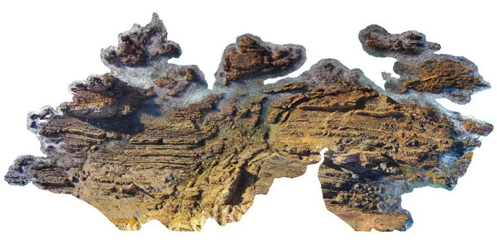
MallacootaUAV2
Site:
MallacootaUAV2
Downloads:
Map
3D Model:
Description:
fault zone cross-cutting folded turbiditic metasediments of the Ordovician Adaminaby Group. Mallacoota, Vic.
| Capture Date: | May 26, 2015, 8:31 a.m. |
| Latitude: | -37.57313000000 degrees |
| Longitude: | 149.76552000000 degrees |
| Elevation: | 1.000 metres |
| Visualisation Type: | UAV |
| Location Accuracy: | 5 metres |
Keywords:
- sandstone
- siltstone
- chert
- fault
- structure
| turbidite | |
|---|---|
| Form Type: | bedded |
| Description: | medium to fine grained cross bedded quartz-mica sandstone with minor shale, and finely laminated shale and siltstone units with an occasional thin chert unit. |
| Min Geological Age: | Darriwilian |
| Max Geological Age: | Ordovician |
| Min Numerical Age: | 458.000 |
| Max Numerical Age: | 485.000 |
| Strat No: | 98 |
| Supergroup: | |
| Group: | Adaminaby Group |
| Subgroup: | |
| Formation: | Pinnak Sandstone |
| Member: | |
| Province: | Lachlan Orogen |