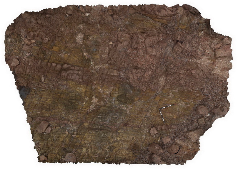
Riley6
Site:
Riley6
Downloads:
Map
3D Model:
Description:
metasediments intruded by numerous tonalite dykes, some of which are folded. The package has been cut by later faults. Point Riley.
| Capture Date: | Oct. 20, 2015, 4:23 p.m. |
| Latitude: | -33.88993000000 degrees |
| Longitude: | 137.61420000000 degrees |
| Elevation: | NA |
| Visualisation Type: | 3D |
| Location Accuracy: | 0 metres |
Keywords:
- metasediments
- tonalite dyke
- fault
- fold
- structure
| sediments | |
|---|---|
| Form Type: | |
| Description: | Biotite schist-dominated unit. Layered, foliated biotite-rich schist of psammitic, argillaceous, calc-silicate, iron rich, graphitic and minor albitic meta-sediments. |
| Min Geological Age: | Paleoproterozoic |
| Max Geological Age: | Paleoproterozoic |
| Min Numerical Age: | 1600.000 |
| Max Numerical Age: | 1741.000 |
| Strat No: | 39166 |
| Supergroup: | |
| Group: | Wallaroo Group |
| Subgroup: | |
| Formation: | |
| Member: | Doora Member |
| Province: | Olympic Domain |
| granite | |
|---|---|
| Form Type: | dyke |
| Description: | Granite, homogeneous, coarse-grained, megacrystic granite. Associated pink, fine to medium-grained granite dykes. |
| Min Geological Age: | Calymmian |
| Max Geological Age: | Calymmian |
| Min Numerical Age: | 1575.000 |
| Max Numerical Age: | 1585.000 |
| Strat No: | 26473 |
| Supergroup: | Hiltaba Supersuite |
| Group: | |
| Subgroup: | |
| Formation: | Charleston Granite |
| Member: | |
| Province: |