Thomson3 Map
 |
5 |
05/18/2015 2:18 p.m. |
3D |
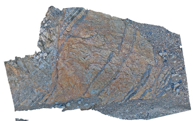
Faults cutting turbiditic sediments of the Devonian Norton Gully Sandstone - main fault zone up to 1m thick. Thomson Dam, Walhalla, Vic. |
10.00 |
-37.84430000000 |
146.39732000000 |
-9999.000 |
turbidite, fault, sedimentology, structure |
turbidite |
Thomson3 Map
 |
5 |
05/18/2015 2:18 p.m. |
3D |
Faults cutting turbiditic sediments of the Devonian Norton Gully Sandstone - main fault zone up to 1m thick. Thomson Dam, Walhalla, Vic. |
10.00 |
-37.84430000000 |
146.39732000000 |
-9999.000 |
turbidite, fault, sedimentology, structure |
turbidite |
Thomson4 Map
 |
5 |
05/18/2015 2:19 p.m. |
3D |
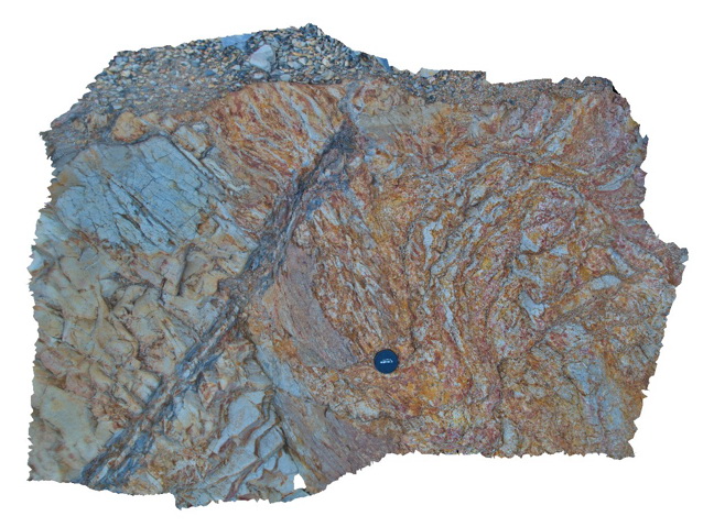
Detail of the fault zone in Devonian Norton Gully Sandstone depicted in Thomson3 - possible drag of layers? Suggesting that the fault may have a reverse sense of movement. Thomson Dam, Walhalla, Vic. |
2.00 |
-37.84430000000 |
146.39732000000 |
-9999.000 |
turbidite, fault zone, structure |
turbidite |
Thomson4 Map
 |
5 |
05/18/2015 2:19 p.m. |
3D |
Detail of the fault zone in Devonian Norton Gully Sandstone depicted in Thomson3 - possible drag of layers? Suggesting that the fault may have a reverse sense of movement. Thomson Dam, Walhalla, Vic. |
2.00 |
-37.84430000000 |
146.39732000000 |
-9999.000 |
turbidite, fault zone, structure |
turbidite |
Thomson5 Map
 |
5 |
05/18/2015 2:19 p.m. |
3D |
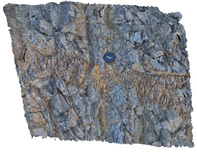
Kink bands in turbiditic sediments of the Devonian Norton Gully Sandstone. Thomson Dam, Walhalla, Vic. |
1.00 |
-37.84430000000 |
146.39732000000 |
-9999.000 |
kink band, turbidite, structure |
turbidite |
Thomson5 Map
 |
5 |
05/18/2015 2:19 p.m. |
3D |
Kink bands in turbiditic sediments of the Devonian Norton Gully Sandstone. Thomson Dam, Walhalla, Vic. |
1.00 |
-37.84430000000 |
146.39732000000 |
-9999.000 |
kink band, turbidite, structure |
turbidite |
Thomson6 Map
 |
5 |
05/18/2015 2:19 p.m. |
3D |
Chevron style synclines and anticlines in turbiditic metasediments of the Devonian Norton Gully Sandstone. Thomson Dam, Walhalla, Vic. |
25.00 |
-37.85546000000 |
146.39876000000 |
-9999.000 |
turbidite, chevron fold, anticline, syncline, structure |
turbidite |
Thomson6 Map
 |
5 |
05/18/2015 2:19 p.m. |
3D |
Chevron style synclines and anticlines in turbiditic metasediments of the Devonian Norton Gully Sandstone. Thomson Dam, Walhalla, Vic. |
25.00 |
-37.85546000000 |
146.39876000000 |
-9999.000 |
turbidite, chevron fold, anticline, syncline, structure |
turbidite |
Thomson6 Map
 |
5 |
05/18/2015 2:19 p.m. |
3D |
Chevron style synclines and anticlines in turbiditic metasediments of the Devonian Norton Gully Sandstone. Thomson Dam, Walhalla, Vic. |
25.00 |
-37.85546000000 |
146.39876000000 |
-9999.000 |
turbidite, chevron fold, anticline, syncline, structure |
turbidite |
Thomson6 Map
 |
5 |
05/18/2015 2:19 p.m. |
3D |
Chevron style synclines and anticlines in turbiditic metasediments of the Devonian Norton Gully Sandstone. Thomson Dam, Walhalla, Vic. |
25.00 |
-37.85546000000 |
146.39876000000 |
-9999.000 |
turbidite, chevron fold, anticline, syncline, structure |
turbidite |
Thomson7 Map
 |
5 |
05/18/2015 2:20 p.m. |
3D |
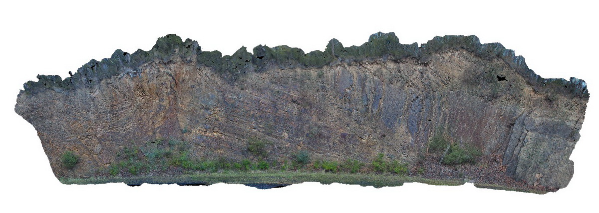
Folds and associated faults cutting turbiditic metasediments of the Devonian Norton Gully Sandstone. Thomson Dam, Walhalla, Vic. |
25.00 |
-37.85506000000 |
146.39720000000 |
530.000 |
turbidite, fault, fold, structure |
turbidite |
Thomson7 Map
 |
5 |
05/18/2015 2:20 p.m. |
3D |
Folds and associated faults cutting turbiditic metasediments of the Devonian Norton Gully Sandstone. Thomson Dam, Walhalla, Vic. |
25.00 |
-37.85506000000 |
146.39720000000 |
530.000 |
turbidite, fault, fold, structure |
turbidite |
Thomson8 Map
 |
5 |
05/18/2015 2:21 p.m. |
3D |
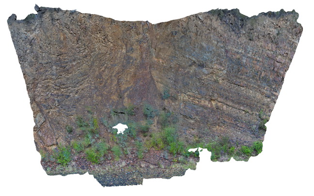
Detail of one of the faults depicted in Thomson 7. The fault cuts turbiditic metasediments of the Devonian Norton Gully Sandstone. Thomson Dam, Walhalla, Vic. |
10.00 |
-37.85513000000 |
146.39734000000 |
530.000 |
turbidite, fault, structure |
turbidite |
Thomson8 Map
 |
5 |
05/18/2015 2:21 p.m. |
3D |
Detail of one of the faults depicted in Thomson 7. The fault cuts turbiditic metasediments of the Devonian Norton Gully Sandstone. Thomson Dam, Walhalla, Vic. |
10.00 |
-37.85513000000 |
146.39734000000 |
530.000 |
turbidite, fault, structure |
turbidite |
Thomson9 Map
 |
5 |
05/18/2015 2:22 p.m. |
3D |
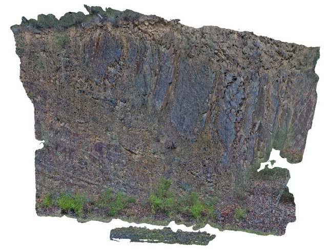
Detail of one of the faults depicted in Thomson 7. The fault cuts turbiditic metasediments of the Devonian Norton Gully Sandstone. Thomson Dam, Walhalla, Vic. |
10.00 |
-37.85505000000 |
146.39711000000 |
530.000 |
turbidite, fault, structure |
turbidite |
Thomson9 Map
 |
5 |
05/18/2015 2:22 p.m. |
3D |
Detail of one of the faults depicted in Thomson 7. The fault cuts turbiditic metasediments of the Devonian Norton Gully Sandstone. Thomson Dam, Walhalla, Vic. |
10.00 |
-37.85505000000 |
146.39711000000 |
530.000 |
turbidite, fault, structure |
turbidite |
Thomson10 Map
 |
5 |
05/18/2015 2:17 p.m. |
3D |
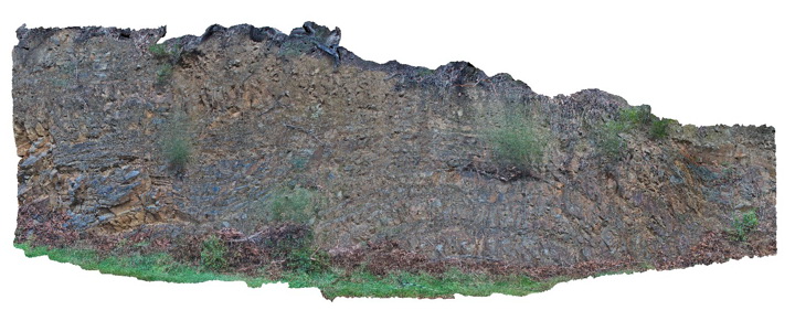
Open anticline and fault in turbiditic metasediments of the Devonian Norton Gully Sandstone. Thomson Dam, Walhalla, Vic. |
20.00 |
-37.85572000000 |
146.39941000000 |
531.000 |
fold, fault, turbidite, structure |
turbidite |
Thomson10 Map
 |
5 |
05/18/2015 2:17 p.m. |
3D |
Open anticline and fault in turbiditic metasediments of the Devonian Norton Gully Sandstone. Thomson Dam, Walhalla, Vic. |
20.00 |
-37.85572000000 |
146.39941000000 |
531.000 |
fold, fault, turbidite, structure |
turbidite |
Thomson10 Map
 |
5 |
05/18/2015 2:17 p.m. |
3D |
Open anticline and fault in turbiditic metasediments of the Devonian Norton Gully Sandstone. Thomson Dam, Walhalla, Vic. |
20.00 |
-37.85572000000 |
146.39941000000 |
531.000 |
fold, fault, turbidite, structure |
turbidite |
Tambo1 Map
 |
5 |
05/18/2015 2:16 p.m. |
3D |
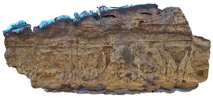
Sandstone of the Pliocene Seaspray Group disconformably overlain by Quaternary gravel. Metung, Vic. |
15.00 |
-37.88462000000 |
147.82196000000 |
-9999.000 |
sandstone, gravel, disconformity, unconformity, sedimentology |
sandstone, gravel |
Tambo1 Map
 |
5 |
05/18/2015 2:16 p.m. |
3D |
Sandstone of the Pliocene Seaspray Group disconformably overlain by Quaternary gravel. Metung, Vic. |
15.00 |
-37.88462000000 |
147.82196000000 |
-9999.000 |
sandstone, gravel, disconformity, unconformity, sedimentology |
sandstone, gravel |
Tambo1 Map
 |
5 |
05/18/2015 2:16 p.m. |
3D |
Sandstone of the Pliocene Seaspray Group disconformably overlain by Quaternary gravel. Metung, Vic. |
15.00 |
-37.88462000000 |
147.82196000000 |
-9999.000 |
sandstone, gravel, disconformity, unconformity, sedimentology |
sandstone, gravel |
Tambo1 Map
 |
5 |
05/18/2015 2:16 p.m. |
3D |
Sandstone of the Pliocene Seaspray Group disconformably overlain by Quaternary gravel. Metung, Vic. |
15.00 |
-37.88462000000 |
147.82196000000 |
-9999.000 |
sandstone, gravel, disconformity, unconformity, sedimentology |
sandstone, gravel |
Buchan1 Map
 |
5 |
07/21/2015 12:36 p.m. |
3D |
Open anticline in layered carbonate sediments of the Taravale Marlstone. Buchan, VIC. |
25.00 |
-37.49040000000 |
148.17535000000 |
-9999.000 |
marl, anticline, fold, structure |
marl |
Buchan1 Map
 |
5 |
07/21/2015 12:36 p.m. |
3D |
Open anticline in layered carbonate sediments of the Taravale Marlstone. Buchan, VIC. |
25.00 |
-37.49040000000 |
148.17535000000 |
-9999.000 |
marl, anticline, fold, structure |
marl |


