Buchan1 Map
 |
5 |
07/21/2015 12:36 p.m. |
3D |
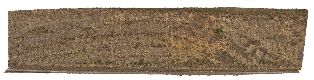
Open anticline in layered carbonate sediments of the Taravale Marlstone. Buchan, VIC. |
25.00 |
-37.49040000000 |
148.17535000000 |
-9999.000 |
marl, anticline, fold, structure |
marl |
Buchan2 Map
 |
10 |
07/21/2015 2 p.m. |
3D |
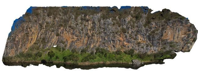
Large outcrop of steeply dipping Buchan Caves Limestone with gentle folds. Buchan, VIC. |
80.00 |
-37.49072000000 |
148.16913000000 |
-9999.000 |
limestone, folds, structure |
Limestone |
Buchan2 Map
|
10 |
07/21/2015 2 p.m. |
3D |
Large outcrop of steeply dipping Buchan Caves Limestone with gentle folds. Buchan, VIC. |
80.00 |
-37.49072000000 |
148.16913000000 |
-9999.000 |
limestone, folds, structure |
Limestone |
Buchan3 Map
 |
10 |
07/21/2015 3:20 p.m. |
3D |
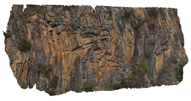
Detail of parasitic fold in Buchan Caves Limestone as depicted in Buchan2. Buchan, VIC. |
20.00 |
-37.49072000000 |
148.16913000000 |
-9999.000 |
limestone, fold, structure |
limestone |
Buchan3 Map
|
10 |
07/21/2015 3:20 p.m. |
3D |
Detail of parasitic fold in Buchan Caves Limestone as depicted in Buchan2. Buchan, VIC. |
20.00 |
-37.49072000000 |
148.16913000000 |
-9999.000 |
limestone, fold, structure |
limestone |
Buchan4 Map
 |
10 |
07/18/2015 2:58 p.m. |
3D |
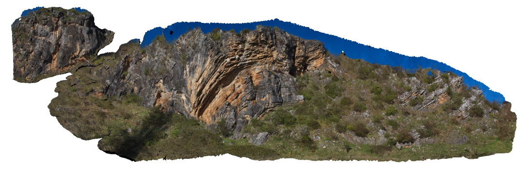
Buchan thrust fault -Folding in the hanging wall in Buchan Caves Limestone. Buchan, VIC. |
100.00 |
-37.50776000000 |
148.21648000000 |
-9999.000 |
limestone, thrust fault, structure |
limestone |
Buchan4 Map
|
10 |
07/18/2015 2:58 p.m. |
3D |
Buchan thrust fault -Folding in the hanging wall in Buchan Caves Limestone. Buchan, VIC. |
100.00 |
-37.50776000000 |
148.21648000000 |
-9999.000 |
limestone, thrust fault, structure |
limestone |
Buchan5 Map
 |
10 |
07/28/2015 11:14 a.m. |
3D |
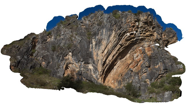
Detail of hanging wall folding above the Buchan Fault folds are in Buchan Caves Limestone. Buchan, VIC. |
40.00 |
-37.50776000000 |
148.21648000000 |
10.000 |
limestone, fold, thrust fault, structure |
limestone |
Buchan5 Map
|
10 |
07/28/2015 11:14 a.m. |
3D |
Detail of hanging wall folding above the Buchan Fault folds are in Buchan Caves Limestone. Buchan, VIC. |
40.00 |
-37.50776000000 |
148.21648000000 |
10.000 |
limestone, fold, thrust fault, structure |
limestone |
Buchan5 Map
|
10 |
07/28/2015 11:14 a.m. |
3D |
Detail of hanging wall folding above the Buchan Fault folds are in Buchan Caves Limestone. Buchan, VIC. |
40.00 |
-37.50776000000 |
148.21648000000 |
10.000 |
limestone, fold, thrust fault, structure |
limestone |
Conran1 Map
 |
5 |
07/21/2015 2:07 p.m. |
3D |
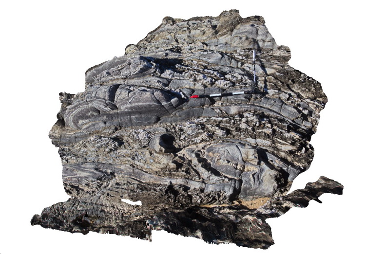
Tight / isoclinal folds and quartz veins in Ordovician Pinnak Sandstone. Cape Conran, Vic. |
3.00 |
-37.79979000000 |
148.74274000000 |
1.000 |
isoclinal fold, turbidite, structure |
turbidite |
Conran1 Map
|
5 |
07/21/2015 2:07 p.m. |
3D |
Tight / isoclinal folds and quartz veins in Ordovician Pinnak Sandstone. Cape Conran, Vic. |
3.00 |
-37.79979000000 |
148.74274000000 |
1.000 |
isoclinal fold, turbidite, structure |
turbidite |
Conran2 Map
 |
5 |
07/18/2015 3:08 p.m. |
3D |
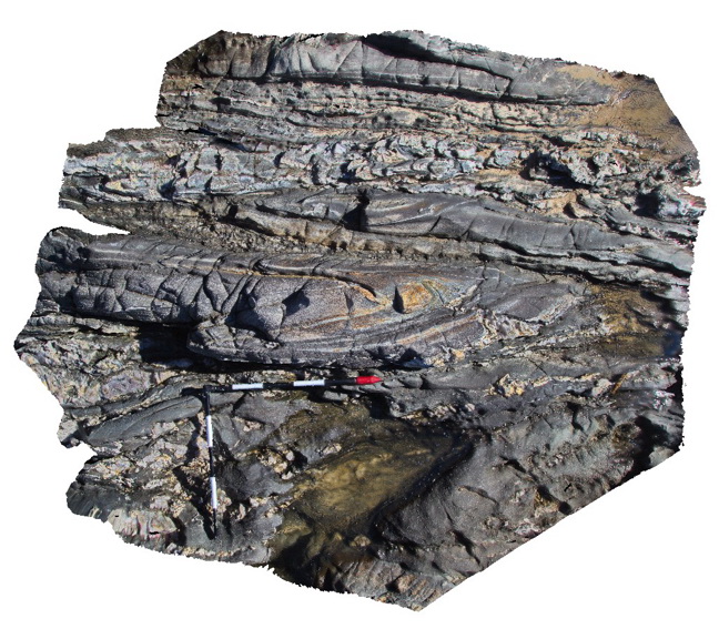
isoclinal fold hinge in Ordovician Pinnak Sandstone turbidites. Cape Conran, Vic. |
2.00 |
-37.80032000000 |
148.74261000000 |
1.000 |
isoclinal fold, structure |
turbidite |
Conran2 Map
|
5 |
07/18/2015 3:08 p.m. |
3D |
isoclinal fold hinge in Ordovician Pinnak Sandstone turbidites. Cape Conran, Vic. |
2.00 |
-37.80032000000 |
148.74261000000 |
1.000 |
isoclinal fold, structure |
turbidite |
Conran3 Map
 |
5 |
07/18/2015 3:09 p.m. |
3D |
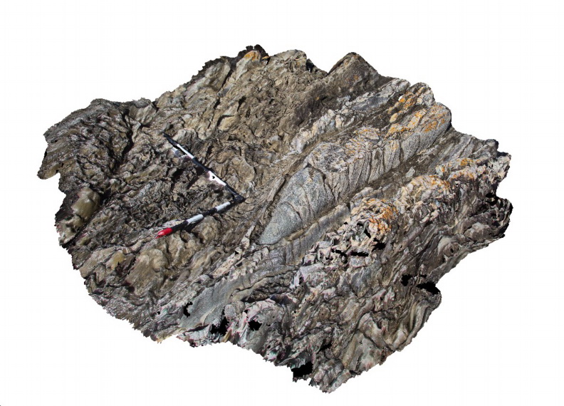
Gently plunging tight to isoclinal fold in turbiditic metasediments of the Ordovician Pinnak Sandstone. Cape Conran, Vic. |
2.00 |
-37.80042000000 |
148.74257000000 |
1.000 |
isoclinal fold, turbidite, structure |
turbidite |
Conran3 Map
|
5 |
07/18/2015 3:09 p.m. |
3D |
Gently plunging tight to isoclinal fold in turbiditic metasediments of the Ordovician Pinnak Sandstone. Cape Conran, Vic. |
2.00 |
-37.80042000000 |
148.74257000000 |
1.000 |
isoclinal fold, turbidite, structure |
turbidite |
Conran4 Map
 |
5 |
07/18/2015 3:10 p.m. |
3D |
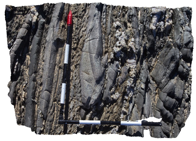
Disrupted isoclinal fold hinge in turbiditic metasediments of the Ordovician Pinnak Sandstone. Axial planar cleavage is well developed in the hinge of the fold. Cape Conran, Vic. |
0.90 |
-37.80046000000 |
148.74255000000 |
-9999.000 |
turbidite, isoclinal fold, cleavage, structure |
turbidite |
Conran4 Map
|
5 |
07/18/2015 3:10 p.m. |
3D |
Disrupted isoclinal fold hinge in turbiditic metasediments of the Ordovician Pinnak Sandstone. Axial planar cleavage is well developed in the hinge of the fold. Cape Conran, Vic. |
0.90 |
-37.80046000000 |
148.74255000000 |
-9999.000 |
turbidite, isoclinal fold, cleavage, structure |
turbidite |
Conran4 Map
|
5 |
07/18/2015 3:10 p.m. |
3D |
Disrupted isoclinal fold hinge in turbiditic metasediments of the Ordovician Pinnak Sandstone. Axial planar cleavage is well developed in the hinge of the fold. Cape Conran, Vic. |
0.90 |
-37.80046000000 |
148.74255000000 |
-9999.000 |
turbidite, isoclinal fold, cleavage, structure |
turbidite |
Conran5 Map
 |
5 |
07/18/2015 3:11 p.m. |
3D |
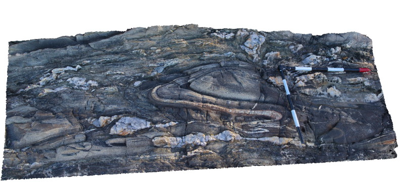
Tight fold in turbiditic metasediments of the Ordovician Pinnak Sandstone. Cape Conran, Vic. |
2.00 |
-37.80064000000 |
148.74240000000 |
1.000 |
turbidite, fold, structure |
turbidite |
Conran5 Map
|
5 |
07/18/2015 3:11 p.m. |
3D |
Tight fold in turbiditic metasediments of the Ordovician Pinnak Sandstone. Cape Conran, Vic. |
2.00 |
-37.80064000000 |
148.74240000000 |
1.000 |
turbidite, fold, structure |
turbidite |
Conran6 Map
 |
5 |
07/18/2015 3:12 p.m. |
3D |
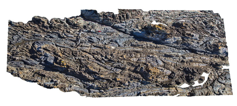
Folded and faulted turbiditic metasediments of the Ordovician Pinnak Sandstone. Cape Conran, Vic. |
5.00 |
-37.80084000000 |
148.74246000000 |
1.000 |
turbidite, fold, fault, structure |
turbidite |
Conran6 Map
|
5 |
07/18/2015 3:12 p.m. |
3D |
Folded and faulted turbiditic metasediments of the Ordovician Pinnak Sandstone. Cape Conran, Vic. |
5.00 |
-37.80084000000 |
148.74246000000 |
1.000 |
turbidite, fold, fault, structure |
turbidite |
Conran6 Map
|
5 |
07/18/2015 3:12 p.m. |
3D |
Folded and faulted turbiditic metasediments of the Ordovician Pinnak Sandstone. Cape Conran, Vic. |
5.00 |
-37.80084000000 |
148.74246000000 |
1.000 |
turbidite, fold, fault, structure |
turbidite |
Conran7 Map
 |
5 |
07/18/2015 3:14 p.m. |
3D |
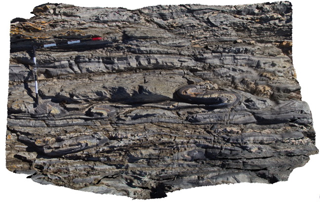
Tight parasitic folds in turbiditic metasediments of the Ordovician Pinnak Sandstone. Cape Conran, Vic. |
2.00 |
-37.80100000000 |
148.74242000000 |
1.000 |
parasitic fold, turbidite, structure |
turbidite |
 AusGeol.org