Prices6 Map
 |
20 |
03/13/2015 9:13 a.m. |
3D |
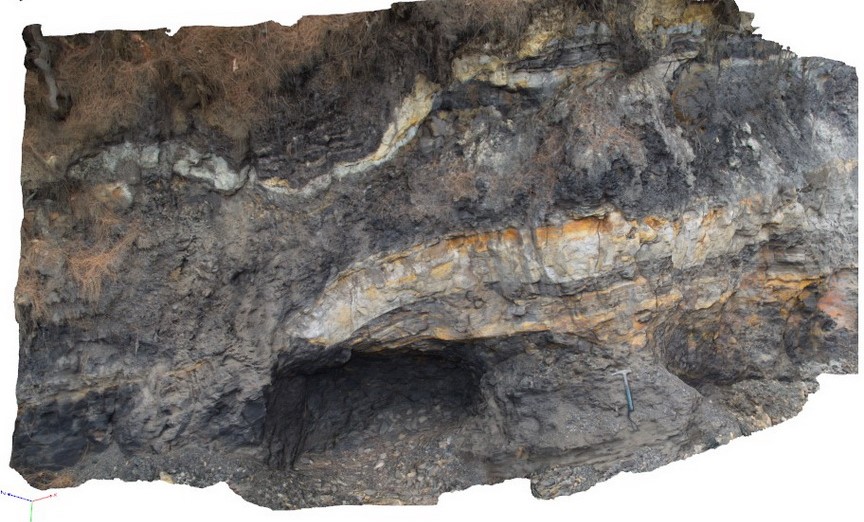
Thrust? Fault cross cutting Triassic carbonaceous siltstone and sandstone. Prices Point, Tasman Peninsula, Tasmania. |
10.00 |
-43.03390900000 |
147.74637700000 |
0.500 |
thrust fault, siltstone, sandstone, fluvial, structure |
siltstone, sandstone |
Prices6 Map
|
20 |
03/13/2015 9:13 a.m. |
3D |
Thrust? Fault cross cutting Triassic carbonaceous siltstone and sandstone. Prices Point, Tasman Peninsula, Tasmania. |
10.00 |
-43.03390900000 |
147.74637700000 |
0.500 |
thrust fault, siltstone, sandstone, fluvial, structure |
siltstone, sandstone |
Prices6 Map
|
20 |
03/13/2015 9:13 a.m. |
3D |
Thrust? Fault cross cutting Triassic carbonaceous siltstone and sandstone. Prices Point, Tasman Peninsula, Tasmania. |
10.00 |
-43.03390900000 |
147.74637700000 |
0.500 |
thrust fault, siltstone, sandstone, fluvial, structure |
siltstone, sandstone |
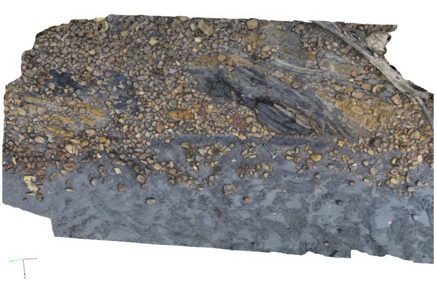
Prices7 Map
 |
20 |
03/13/2015 9:13 a.m. |
3D |
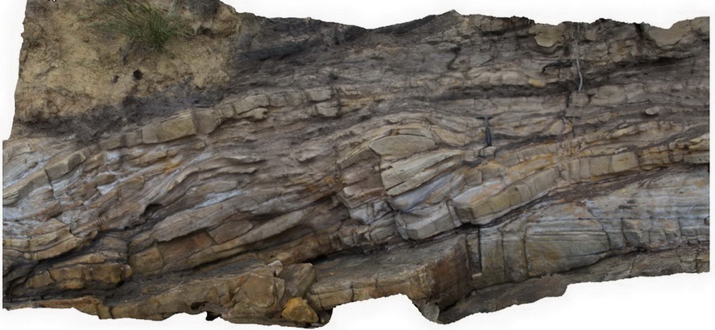
Cross beds and channels in Triassic fluvial sediments. Prices Point, Tasman Peninsula, Tasmania. |
10.00 |
-43.03379200000 |
147.74610800000 |
0.500 |
sandstone, cross beds, fluvial, channel, sedimentology |
sandstone |
Prices7 Map
|
20 |
03/13/2015 9:13 a.m. |
3D |
Cross beds and channels in Triassic fluvial sediments. Prices Point, Tasman Peninsula, Tasmania. |
10.00 |
-43.03379200000 |
147.74610800000 |
0.500 |
sandstone, cross beds, fluvial, channel, sedimentology |
sandstone |
Prices7 Map
|
20 |
03/13/2015 9:13 a.m. |
3D |
Cross beds and channels in Triassic fluvial sediments. Prices Point, Tasman Peninsula, Tasmania. |
10.00 |
-43.03379200000 |
147.74610800000 |
0.500 |
sandstone, cross beds, fluvial, channel, sedimentology |
sandstone |
Prices7 Map
|
20 |
03/13/2015 9:13 a.m. |
3D |
Cross beds and channels in Triassic fluvial sediments. Prices Point, Tasman Peninsula, Tasmania. |
10.00 |
-43.03379200000 |
147.74610800000 |
0.500 |
sandstone, cross beds, fluvial, channel, sedimentology |
sandstone |
Prices8 Map
 |
20 |
03/13/2015 9:13 a.m. |
3D |
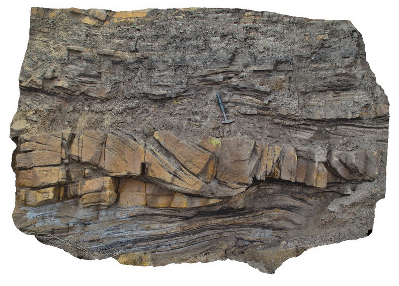
Triassic fluvial/floodplain sediments. Prices Point, Tasman Peninsula, Tasmania. |
10.00 |
-43.03366100000 |
147.74592300000 |
0.500 |
fluvial, floodplain, sedimentology |
sandstone |
Prices8 Map
|
20 |
03/13/2015 9:13 a.m. |
3D |
Triassic fluvial/floodplain sediments. Prices Point, Tasman Peninsula, Tasmania. |
10.00 |
-43.03366100000 |
147.74592300000 |
0.500 |
fluvial, floodplain, sedimentology |
sandstone |
Prices9 Map
 |
20 |
03/13/2015 9:13 a.m. |
3D |
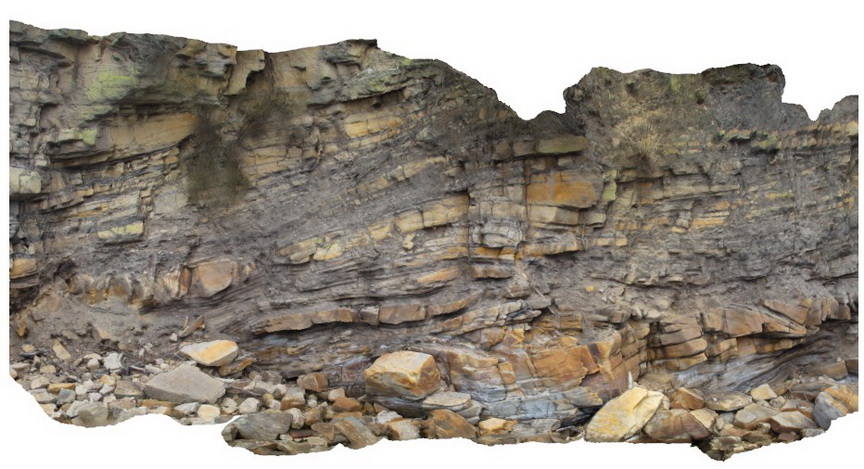
Cross bedded channel sandstone body in fine grained carbonaceous floodplain sediments. Prices Point, Tasman Peninsula, Tasmania. |
5.00 |
-43.03359100000 |
147.74572400000 |
0.500 |
channel, cross bed, fluvial, floodplain, sedimentology |
sandstone, siltstone |
Prices9 Map
|
20 |
03/13/2015 9:13 a.m. |
3D |
Cross bedded channel sandstone body in fine grained carbonaceous floodplain sediments. Prices Point, Tasman Peninsula, Tasmania. |
5.00 |
-43.03359100000 |
147.74572400000 |
0.500 |
channel, cross bed, fluvial, floodplain, sedimentology |
sandstone, siltstone |
Prices10 Map
 |
20 |
03/13/2015 9:12 a.m. |
3D |
Fault contact in the shore platform between steeply dipping carbonaceous siltstone and horizontal siltstone - thrust fault? Prices Point, Tasman Peninsula, Tasmania. |
10.00 |
-43.03404100000 |
147.74658500000 |
0.500 |
fault, structure |
siltstone |
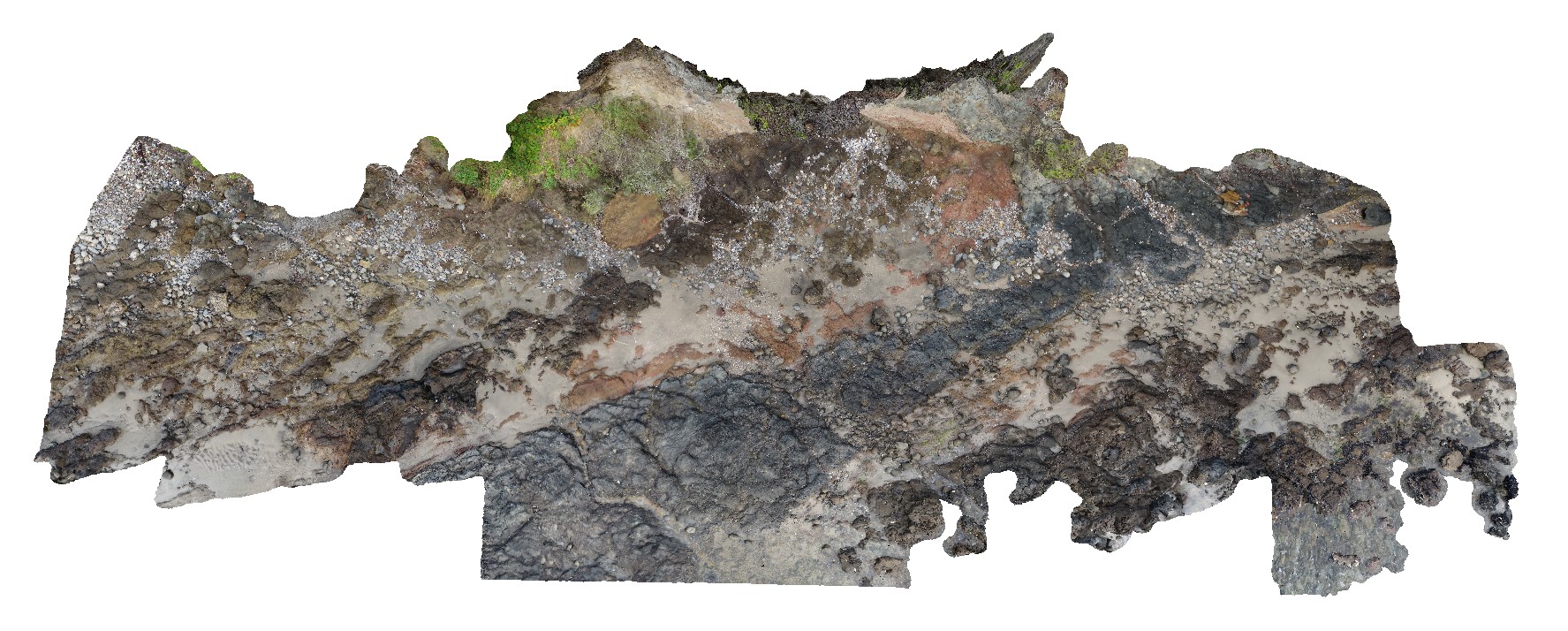
SBay1 Map
 |
20 |
03/13/2015 9:17 a.m. |
3D |
Pole photography of the Charles Darwin Cliff at Sandy Bay. Tertiary basaltic lava flows and pyroclastic material deposited from a small volcanic vent approximately 200m to the west |
25.00 |
-42.91649600000 |
147.36026000000 |
-9999.000 |
basalt, tuff, agglomerate, volcanology, igneous |
basalt, tuff |
SBay1 Map
|
20 |
03/13/2015 9:17 a.m. |
3D |
Pole photography of the Charles Darwin Cliff at Sandy Bay. Tertiary basaltic lava flows and pyroclastic material deposited from a small volcanic vent approximately 200m to the west |
25.00 |
-42.91649600000 |
147.36026000000 |
-9999.000 |
basalt, tuff, agglomerate, volcanology, igneous |
basalt, tuff |
Schanck1 Map
 |
5 |
05/18/2015 1:35 p.m. |
3D |
Black, vesicular columnar basalt flow underlain by a layer of brown matrix supported volcanic breccia. Cape Schanck, Vic. |
5.00 |
-38.49791000000 |
144.88953000000 |
3.000 |
columnar basalt, vesicular basalt, volcanic breccia, volcanology, igneous |
basalt, breccia |
Schanck1 Map
|
5 |
05/18/2015 1:35 p.m. |
3D |
Black, vesicular columnar basalt flow underlain by a layer of brown matrix supported volcanic breccia. Cape Schanck, Vic. |
5.00 |
-38.49791000000 |
144.88953000000 |
3.000 |
columnar basalt, vesicular basalt, volcanic breccia, volcanology, igneous |
basalt, breccia |
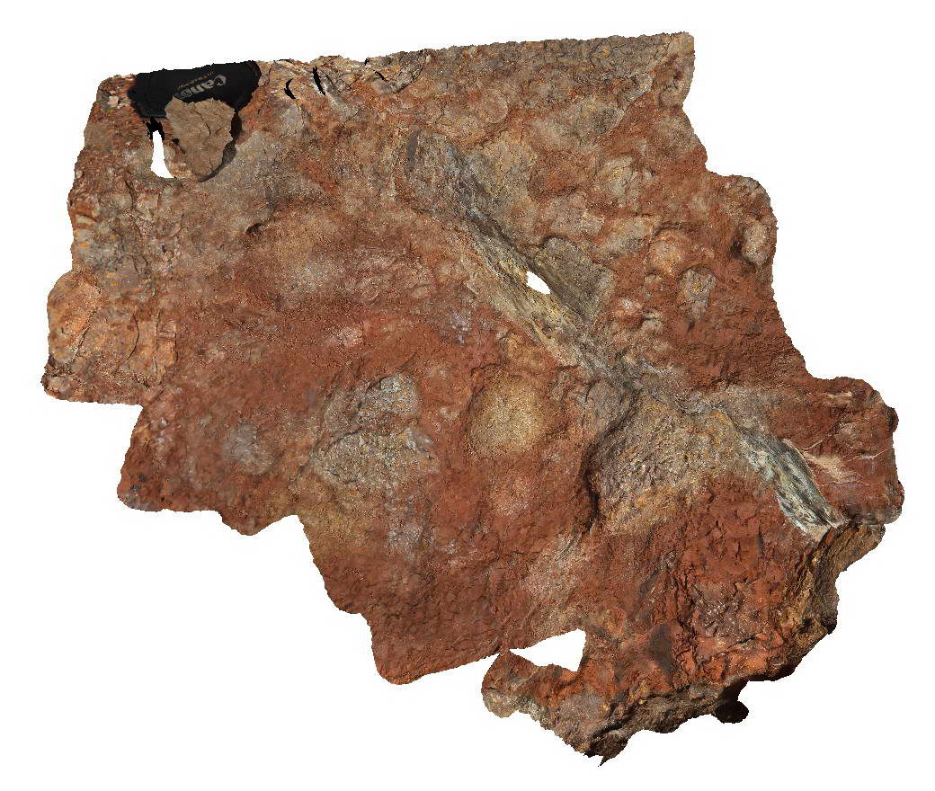
Schanck2 Map
 |
5 |
05/18/2015 1:36 p.m. |
3D |
Brown volcanic breccia layer. This is a detailed view of a portion of the Schanck1 visualisation. Cape Schanck, Vic. |
0.50 |
-38.49791000000 |
144.88953000000 |
3.000 |
volcanic breccia, volcanology |
breccia |
Schanck3 Map
 |
5 |
05/18/2015 1:36 p.m. |
3D |
Flow boundary between a lower sparsely vesicular basalt and an upper densely vesicular basalt. Cape Schanck, Vic. |
5.00 |
-38.49907000000 |
144.88911000000 |
2.000 |
vesicular basalt, volcanology, igneous |
basalt |
Schanck4 Map
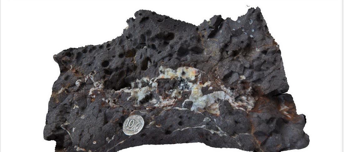 |
5 |
05/18/2015 1:37 p.m. |
3D |
Detail of zeolite veins in vesicular basalt. Detail of veins shown in Schanck3. Cape Schanck, Vic. |
0.30 |
-38.49907000000 |
144.88911000000 |
2.000 |
vesicular basalt, zeolite, volcanology, igneous |
basalt |
Schanck4 Map
|
5 |
05/18/2015 1:37 p.m. |
3D |
Detail of zeolite veins in vesicular basalt. Detail of veins shown in Schanck3. Cape Schanck, Vic. |
0.30 |
-38.49907000000 |
144.88911000000 |
2.000 |
vesicular basalt, zeolite, volcanology, igneous |
basalt |
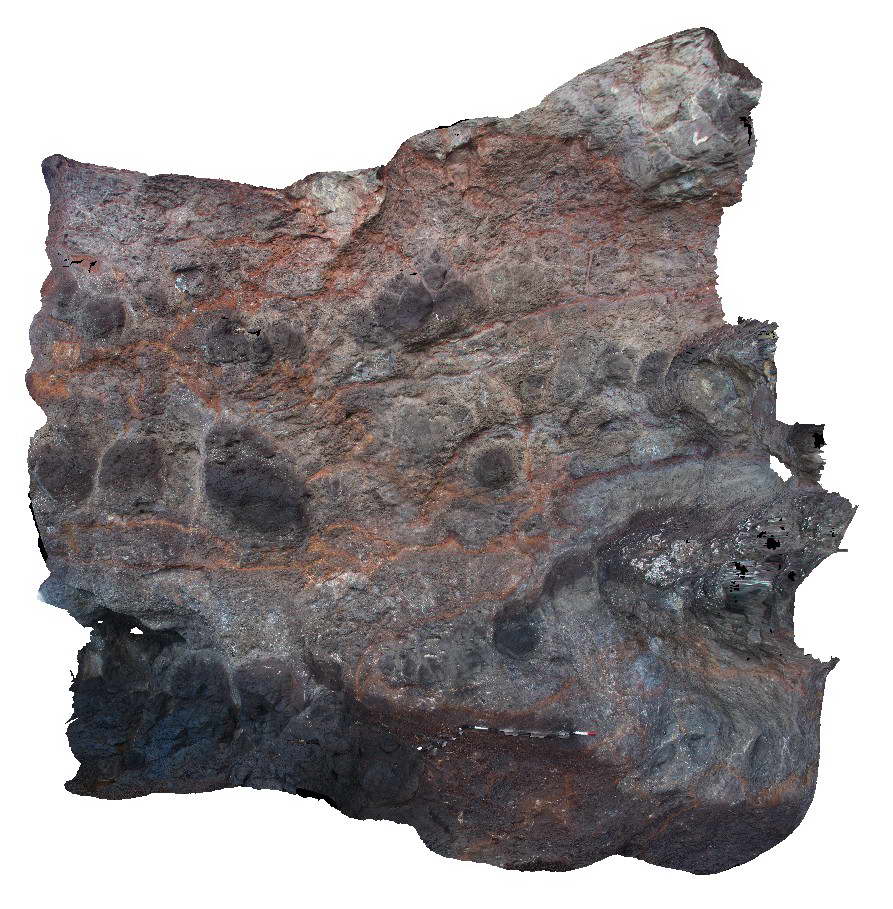
Schanck5 Map
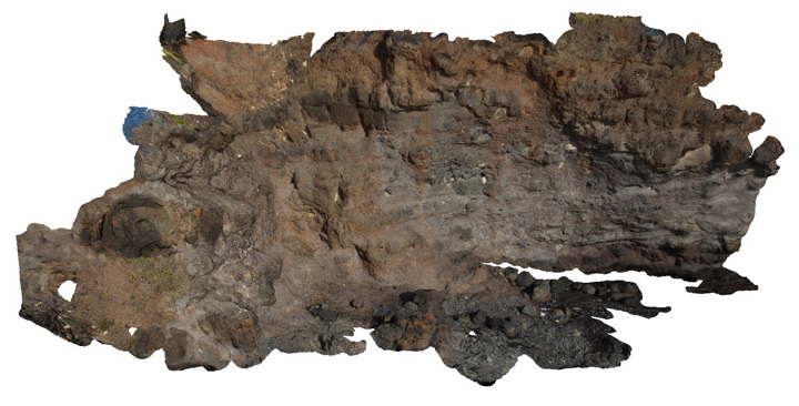 |
5 |
05/18/2015 1:37 p.m. |
3D |
Large outcrop showing multiple layers of basaltic lava flows and pyroclastic layers. Cape Schanck, Vic. |
30.00 |
-38.49773000000 |
144.88753000000 |
0.000 |
basalt flows, pyroclastic, volcanology, igneous |
basalt |