Schanck6 Map
 |
5 |
05/18/2015 1:38 p.m. |
3D |
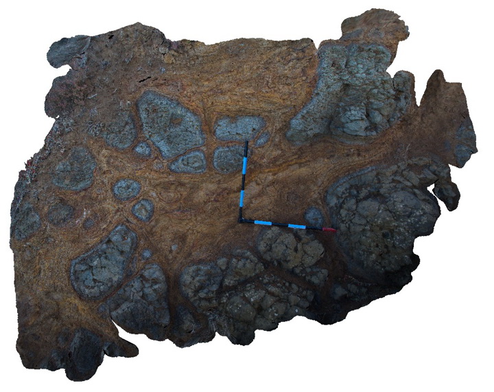
Spheroidal weathering of basalt. Cape Schanck, Vic. |
2.00 |
-38.49649000000 |
144.88792000000 |
15.000 |
basalt, spheroidal weathering, regolith, volcanology |
basalt |
Schanck6 Map
|
5 |
05/18/2015 1:38 p.m. |
3D |
Spheroidal weathering of basalt. Cape Schanck, Vic. |
2.00 |
-38.49649000000 |
144.88792000000 |
15.000 |
basalt, spheroidal weathering, regolith, volcanology |
basalt |
Schanck7 Map
 |
5 |
05/18/2015 1:38 p.m. |
3D |
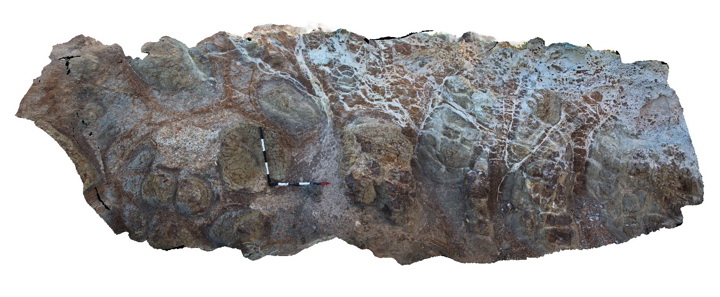
Spheroidal weathering of basalt with carbonate veins from overlying calcarenite. Cape Schanck, Vic. |
2.00 |
-38.49611000000 |
144.88782000000 |
15.000 |
basalt, spheroidal weathering, carbonate veins, volcanology |
basalt |
Schanck7 Map
|
5 |
05/18/2015 1:38 p.m. |
3D |
Spheroidal weathering of basalt with carbonate veins from overlying calcarenite. Cape Schanck, Vic. |
2.00 |
-38.49611000000 |
144.88782000000 |
15.000 |
basalt, spheroidal weathering, carbonate veins, volcanology |
basalt |
Schanck7 Map
|
5 |
05/18/2015 1:38 p.m. |
3D |
Spheroidal weathering of basalt with carbonate veins from overlying calcarenite. Cape Schanck, Vic. |
2.00 |
-38.49611000000 |
144.88782000000 |
15.000 |
basalt, spheroidal weathering, carbonate veins, volcanology |
basalt |
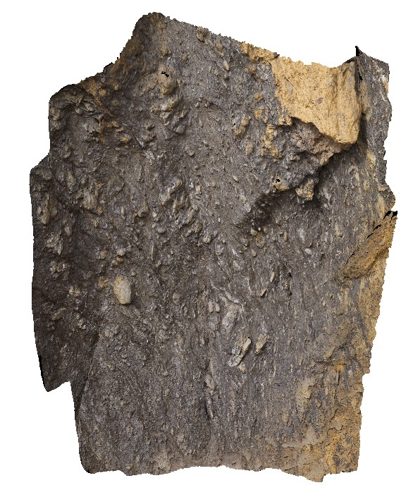
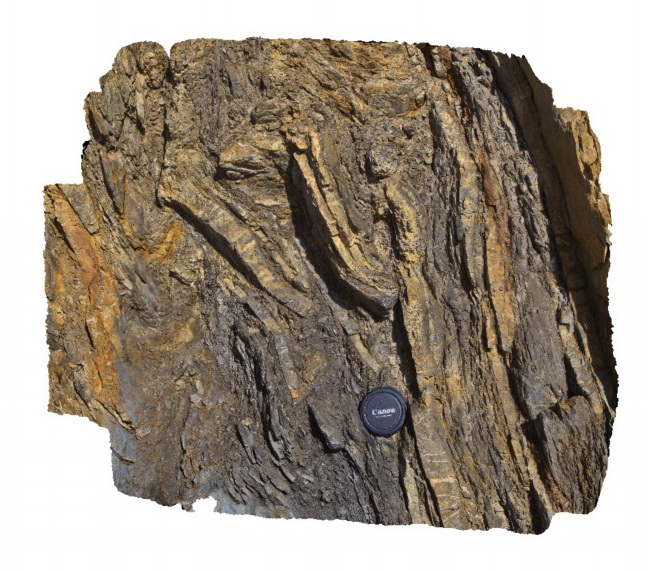
Schanck8 Map
 |
5 |
05/18/2015 1:39 p.m. |
3D |
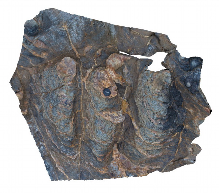
Weathered basalt with prominent sub-horizontal and vertical 'zeolite' veins. Cape Schanck, Vic. |
1.50 |
-38.48315000000 |
145.02116000000 |
0.000 |
basalt, zeolite veins, weathering, igneous |
basalt |
Schanck8 Map
|
5 |
05/18/2015 1:39 p.m. |
3D |
Weathered basalt with prominent sub-horizontal and vertical 'zeolite' veins. Cape Schanck, Vic. |
1.50 |
-38.48315000000 |
145.02116000000 |
0.000 |
basalt, zeolite veins, weathering, igneous |
basalt |
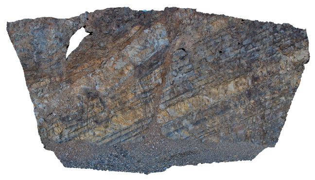
Walkerville1 Map
 |
5 |
05/18/2015 2:23 p.m. |
3D |
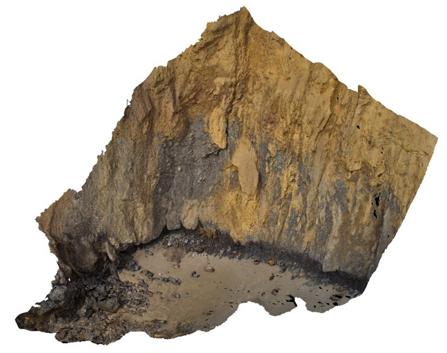
Contact between the Liptrap Formation sandstone and limestone. Contact is a fault melange. Walkerville South, Vic. |
15.00 |
-38.85546000000 |
145.99707000000 |
-9999.000 |
fault, structure, melange |
melange |
Walkerville2 Map
 |
5 |
05/18/2015 2:23 p.m. |
3D |
Detail of fault melange shown in Walkerville1. Exposure is 5-10 m up the cliff - maximum clast size is ~0.5m. Walkerville South, Vic. |
6.00 |
-38.85546000000 |
145.99707000000 |
-9999.000 |
fault, melange, structure |
melange |
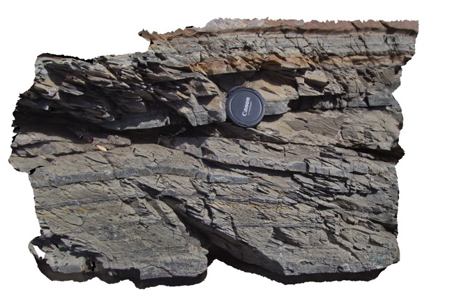
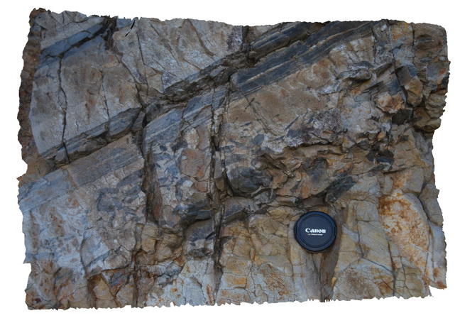
Walkerville4 Map
 |
5 |
05/18/2015 2:24 p.m. |
3D |
Fault at a low angle to bedding in thinly bedded sandstone and siltstone of the Liptrap Formation. Walkerville South, Vic. |
4.00 |
-38.85529500000 |
145.99678000000 |
1.000 |
fault, structure, turbidite |
sandstone, siltstone |
Walkerville5 Map
 |
5 |
05/18/2015 2:24 p.m. |
3D |
bedding - cleavage relationship and small fault in distal turbidites of the Liptrap Formation. Walkerville South, Vic. |
1.00 |
-38.85517000000 |
145.99669000000 |
1.000 |
turbidite, bedding - cleavage relationship, fault, structure, sedimentology |
turbidite |
Walkerville5 Map
|
5 |
05/18/2015 2:24 p.m. |
3D |
bedding - cleavage relationship and small fault in distal turbidites of the Liptrap Formation. Walkerville South, Vic. |
1.00 |
-38.85517000000 |
145.99669000000 |
1.000 |
turbidite, bedding - cleavage relationship, fault, structure, sedimentology |
turbidite |
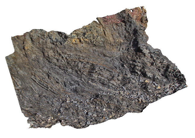
Walkerville6 Map
 |
5 |
05/18/2015 2:25 p.m. |
3D |
Complex folds and faults in distal turbidites of the Liptrap Formation. Walkerville South, Vic. |
3.00 |
-38.85467000000 |
145.99640000000 |
1.000 |
turbidite, folds, faults, structure |
turbidite |
Walkerville6 Map
|
5 |
05/18/2015 2:25 p.m. |
3D |
Complex folds and faults in distal turbidites of the Liptrap Formation. Walkerville South, Vic. |
3.00 |
-38.85467000000 |
145.99640000000 |
1.000 |
turbidite, folds, faults, structure |
turbidite |
Walkerville6 Map
|
5 |
05/18/2015 2:25 p.m. |
3D |
Complex folds and faults in distal turbidites of the Liptrap Formation. Walkerville South, Vic. |
3.00 |
-38.85467000000 |
145.99640000000 |
1.000 |
turbidite, folds, faults, structure |
turbidite |
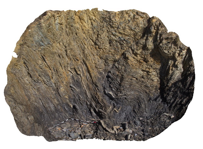
Walkerville7 Map
 |
5 |
05/18/2015 2:25 p.m. |
3D |
Detailed view of disrupted folds in turbidites of the Liptrap Formation - detail of Walkerville 6 visualisation. Walkerville South, Vic. |
1.00 |
-38.85467000000 |
145.99669000000 |
-9999.000 |
fold, fault, turbidite, structure |
turbidite |
Walkerville7 Map
|
5 |
05/18/2015 2:25 p.m. |
3D |
Detailed view of disrupted folds in turbidites of the Liptrap Formation - detail of Walkerville 6 visualisation. Walkerville South, Vic. |
1.00 |
-38.85467000000 |
145.99669000000 |
-9999.000 |
fold, fault, turbidite, structure |
turbidite |
Walkerville7 Map
|
5 |
05/18/2015 2:25 p.m. |
3D |
Detailed view of disrupted folds in turbidites of the Liptrap Formation - detail of Walkerville 6 visualisation. Walkerville South, Vic. |
1.00 |
-38.85467000000 |
145.99669000000 |
-9999.000 |
fold, fault, turbidite, structure |
turbidite |
Thomson1 Map
 |
5 |
05/18/2015 2:17 p.m. |
3D |
normal? fault in dipping turbidites near the Thomson Dam - fault zone approx. 30 cm wide. Thomson Dam, Walhalla, Vic. |
8.00 |
-37.84397000000 |
146.39761000000 |
-9999.000 |
fault, turbidite, structure, sedimentology |
turbidite |
Thomson1 Map
|
5 |
05/18/2015 2:17 p.m. |
3D |
normal? fault in dipping turbidites near the Thomson Dam - fault zone approx. 30 cm wide. Thomson Dam, Walhalla, Vic. |
8.00 |
-37.84397000000 |
146.39761000000 |
-9999.000 |
fault, turbidite, structure, sedimentology |
turbidite |
Thomson2 Map
 |
5 |
05/18/2015 2:17 p.m. |
3D |
Detail of mudstone rip up clasts in sandstone matrix - same exposure as Thomson1. Thomson Dam, Walhalla, Vic. |
0.50 |
-37.84397000000 |
146.39761000000 |
-9999.000 |
sandstone, siltstone, turbidite, rip-up clasts, sedimentology |
sandstone |
Thomson2 Map
|
5 |
05/18/2015 2:17 p.m. |
3D |
Detail of mudstone rip up clasts in sandstone matrix - same exposure as Thomson1. Thomson Dam, Walhalla, Vic. |
0.50 |
-37.84397000000 |
146.39761000000 |
-9999.000 |
sandstone, siltstone, turbidite, rip-up clasts, sedimentology |
sandstone |
Thomson2 Map
|
5 |
05/18/2015 2:17 p.m. |
3D |
Detail of mudstone rip up clasts in sandstone matrix - same exposure as Thomson1. Thomson Dam, Walhalla, Vic. |
0.50 |
-37.84397000000 |
146.39761000000 |
-9999.000 |
sandstone, siltstone, turbidite, rip-up clasts, sedimentology |
sandstone |
Thomson2 Map
|
5 |
05/18/2015 2:17 p.m. |
3D |
Detail of mudstone rip up clasts in sandstone matrix - same exposure as Thomson1. Thomson Dam, Walhalla, Vic. |
0.50 |
-37.84397000000 |
146.39761000000 |
-9999.000 |
sandstone, siltstone, turbidite, rip-up clasts, sedimentology |
sandstone |