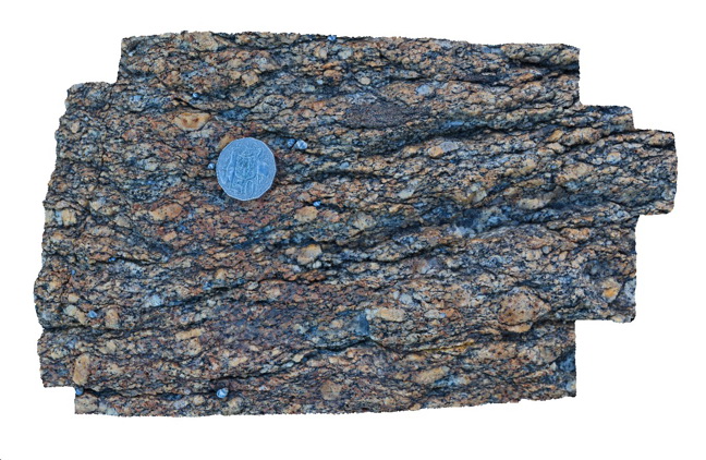
Conran13 Map
 |
1 |
08/04/2015 10:03 a.m. |
3D |
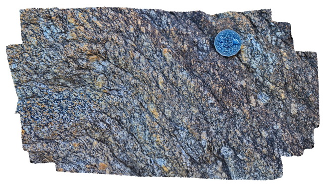
Porphyritic granite from the margin of the Cape Conran Granite with well defined shear fabric. Cape Conran, Vic. |
0.30 |
-37.80811100000 |
148.73338000000 |
1.000 |
granite, shear, s-c fabric, igneous, structure |
granite |
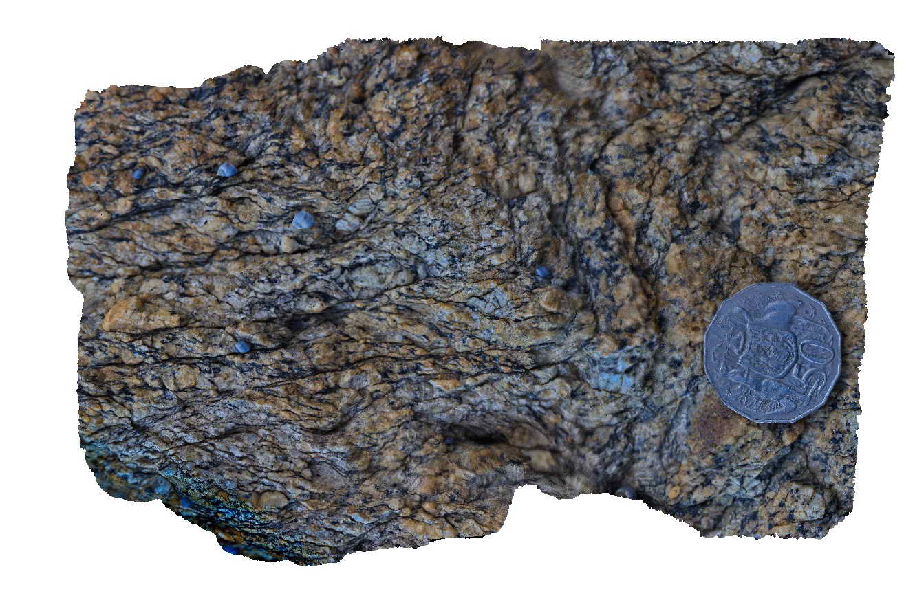
Conran14 Map
 |
5 |
07/18/2015 3:21 p.m. |
3D |
Shear textures in granite on the margin of the Cape Conran Granite. Cape Conran, Vic. |
0.20 |
-37.80819000000 |
148.73337000000 |
1.000 |
granite, shear, s-c fabric, structure, igneous |
granite |
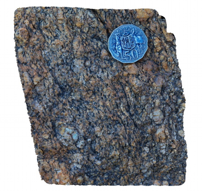
Conran15 Map
 |
5 |
08/04/2015 10:26 a.m. |
3D |
s-c texture in equigranular granite on the margin of the Cape Conran Granite. Cape Conran, Vic. |
0.20 |
-37.80819000000 |
148.73337000000 |
1.000 |
granite, shear, s-s fabric, structure, igneous |
granite |
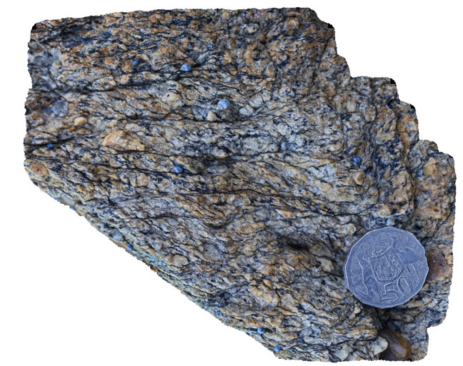
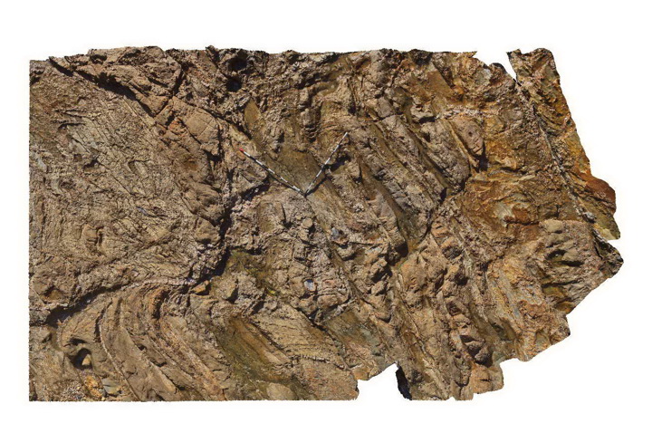
Conran16 Map
 |
5 |
08/04/2015 10:35 a.m. |
3D |
s-c fabric in Cape Conran Granite. Cape Conran, Vic. |
0.20 |
-37.80819000000 |
148.73337000000 |
1.000 |
granite, shear, s-c fabric, igneous, structure |
granite |
Conran16b Map
 |
5 |
07/18/2015 3:23 p.m. |
3D |
Shear textures (s-c fabric) in Cape Conran Granite. Shear fabric appears to have been folded? Cape Conran, Vic. |
0.30 |
-37.80819000000 |
148.73337000000 |
1.000 |
granite, shear, s-c fabric, structure |
granite |
Conran17 Map
 |
5 |
07/18/2015 3:25 p.m. |
3D |
Granitic dykes from the Cape Conran Granite intruding contact metamorphosed turbiditic metasediments of the Ordovician Pinnak Sandstone. Cape Conran, Vic. |
5.00 |
-37.80782000000 |
148.73389000000 |
1.000 |
turbidite, granite, dyke, igneous, structure |
turbidite, Granite |
Conran17 Map
|
5 |
07/18/2015 3:25 p.m. |
3D |
Granitic dykes from the Cape Conran Granite intruding contact metamorphosed turbiditic metasediments of the Ordovician Pinnak Sandstone. Cape Conran, Vic. |
5.00 |
-37.80782000000 |
148.73389000000 |
1.000 |
turbidite, granite, dyke, igneous, structure |
turbidite, Granite |
Mallacoota3 Map
 |
5 |
05/18/2015 1:56 p.m. |
3D |
Cross bedded sandstone of the Ordovician Adaminaby Group. Mallacoota, Vic. |
0.40 |
-37.57332000000 |
149.76556000000 |
1.000 |
sandstone, cross bed, sedimentology |
sandstone |
Mallacoota4 Map
 |
5 |
05/18/2015 1:56 p.m. |
3D |
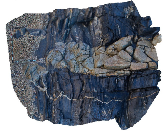
Exotic blocks of basalt and chert within 'accretionary complex' melange in Ordovician Adaminaby Group metasediments Mallacoota, Vic. |
2.00 |
-37.57347000000 |
149.76556000000 |
1.000 |
basalt, chert, melange, structure |
basalt, chert, sandstone |
Mallacoota4 Map
|
5 |
05/18/2015 1:56 p.m. |
3D |
Exotic blocks of basalt and chert within 'accretionary complex' melange in Ordovician Adaminaby Group metasediments Mallacoota, Vic. |
2.00 |
-37.57347000000 |
149.76556000000 |
1.000 |
basalt, chert, melange, structure |
basalt, chert, sandstone |
Mallacoota5 Map
 |
5 |
05/18/2015 1:56 p.m. |
3D |
Folded turbidites of the Ordovician Adaminaby Group showing two generations of folds, faults and exotic blocks. Mallacoota, Vic. |
6.00 |
-37.57306000000 |
149.76546000000 |
1.000 |
turbidite, fold, fault, structure, sedimentology |
turbidite |
Armidale1 Map
 |
5 |
10/06/2015 11:03 a.m. |
3D |
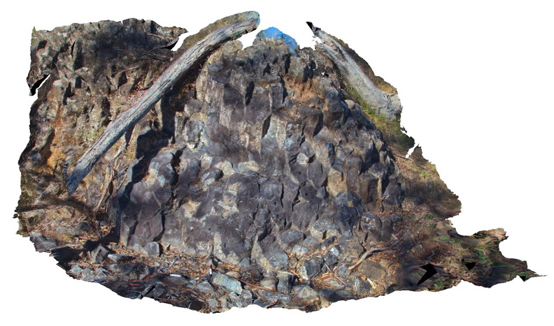
Tertiary columnar basalt with mantle xenoliths. Armidale, N.S.W |
5.00 |
-30.48196000000 |
151.63914000000 |
-9999.000 |
basalt, columnar jointing, igneous |
basalt |
Armidale2 Map
 |
5 |
07/27/2015 10:20 a.m. |
3D |
Detail of mantle xenoliths in Tertiary basalt at site of Armidale1. Armidale, N.S.W |
0.50 |
-30.48196000000 |
151.63914000000 |
-9999.000 |
basalt, xenolith |
basalt |
Armidale3 Map
 |
5 |
07/27/2015 10:33 a.m. |
3D |
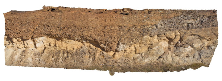
Conglomerate channel cut into underlying sandstone in the Eocene-Oligocene Armidale beds. Armidale, N.S.W |
12.00 |
-30.49301000000 |
151.65099000000 |
-9999.000 |
conglomerate, sandstone, channel |
sandstone, conglomerate |
Armidale3 Map
|
5 |
07/27/2015 10:33 a.m. |
3D |
Conglomerate channel cut into underlying sandstone in the Eocene-Oligocene Armidale beds. Armidale, N.S.W |
12.00 |
-30.49301000000 |
151.65099000000 |
-9999.000 |
conglomerate, sandstone, channel |
sandstone, conglomerate |
Armidale4 Map
 |
5 |
07/27/2015 10:33 a.m. |
3D |
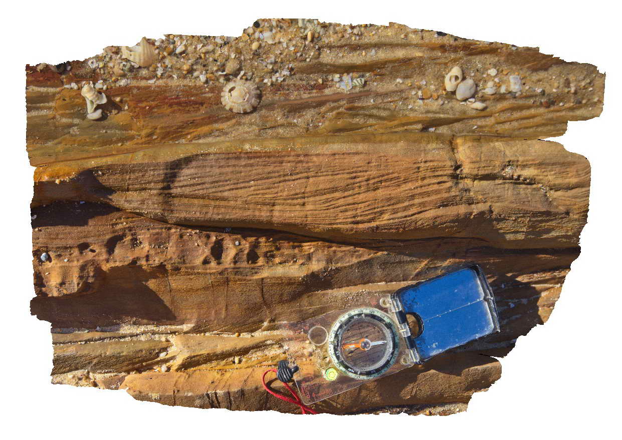
Liesegang bands in Eocene-Oligocene sandstone of the Armidale beds. Armidale, N.S.W |
20.00 |
-30.49326000000 |
151.65179000000 |
-9999.000 |
sandstone, liesegang bands |
sandstone |
Armidale5 Map
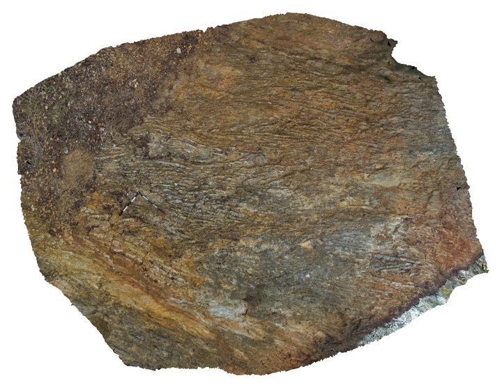 |
5 |
10/06/2015 10:52 a.m. |
3D |
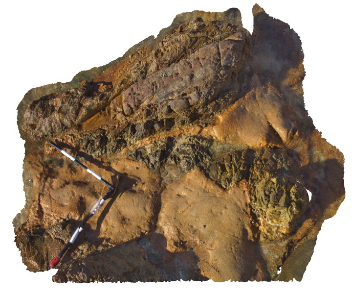
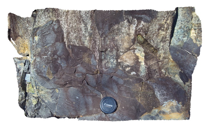
Tightly folded chert and mudstone beds within the Devonian to Carboniferous Sandon Beds. Armidale, N.S.W |
5.00 |
-30.57193000000 |
151.64053000000 |
-9999.000 |
chert, mudstone, fold |
chert, mudstone |
Armidale5 Map
|
5 |
10/06/2015 10:52 a.m. |
3D |
Tightly folded chert and mudstone beds within the Devonian to Carboniferous Sandon Beds. Armidale, N.S.W |
5.00 |
-30.57193000000 |
151.64053000000 |
-9999.000 |
chert, mudstone, fold |
chert, mudstone |
Armidale6 Map
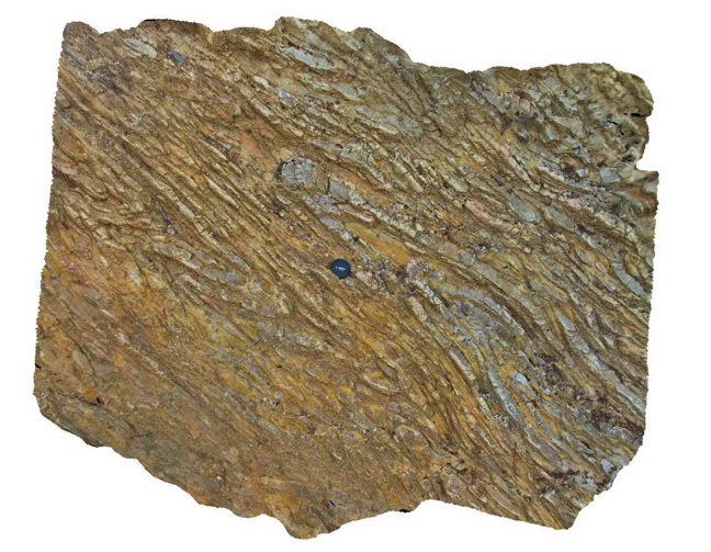 |
5 |
07/27/2015 10:35 a.m. |
3D |
Detail of the folded chert layers and mudstone layers within the Devonian-Carboniferous Sandon Beds. Armidale, N.S.W |
2.00 |
-30.57193000000 |
151.64053000000 |
-9999.000 |
chert, mudstone, reclined fold |
chert, mudstone |
Armidale6 Map
|
5 |
07/27/2015 10:35 a.m. |
3D |
Detail of the folded chert layers and mudstone layers within the Devonian-Carboniferous Sandon Beds. Armidale, N.S.W |
2.00 |
-30.57193000000 |
151.64053000000 |
-9999.000 |
chert, mudstone, reclined fold |
chert, mudstone |
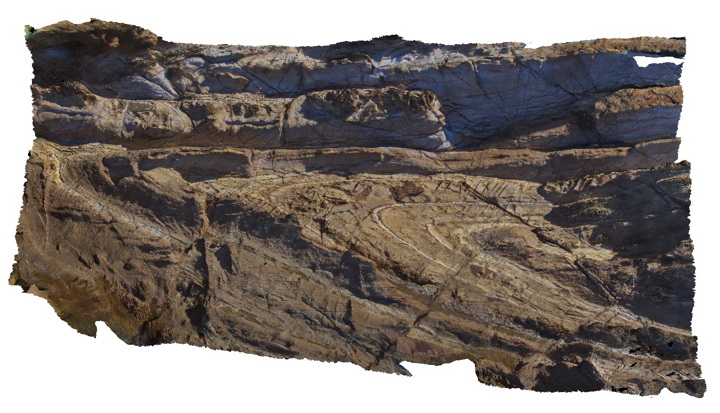
Armidale7 Map
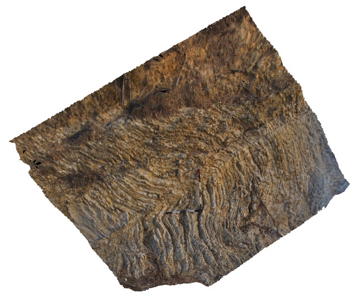 |
5 |
07/27/2015 10:35 a.m. |
3D |
Folded and faulted thin chert and mudstone layers of the Devonian to Carboniferous Sandon Beds with overlying transported regolith. Armidale, N.S.W |
4.00 |
-30.57199000000 |
151.64069000000 |
-9999.000 |
chert, mudstone, fold, fault, regolith |
chert, mudstone |
Armidale7 Map
|
5 |
07/27/2015 10:35 a.m. |
3D |
Folded and faulted thin chert and mudstone layers of the Devonian to Carboniferous Sandon Beds with overlying transported regolith. Armidale, N.S.W |
4.00 |
-30.57199000000 |
151.64069000000 |
-9999.000 |
chert, mudstone, fold, fault, regolith |
chert, mudstone |
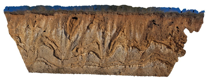
Armidale8 Map
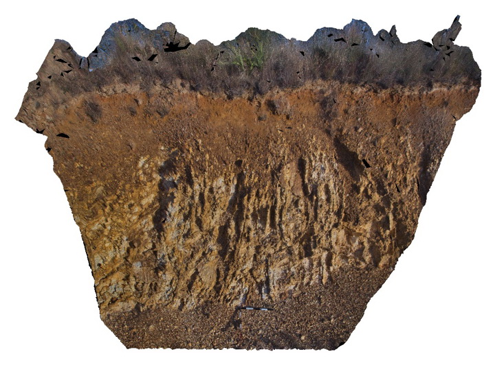 |
5 |
10/06/2015 1:43 p.m. |
3D |
Regolith profile over folded Devonian to Carboniferous Sandon Beds. Armidale, N.S.W |
4.00 |
-30.56921000000 |
151.64027000000 |
-9999.000 |
regolith, chert, mudstone |
chert, mudstone |
Armidale8 Map
|
5 |
10/06/2015 1:43 p.m. |
3D |
Regolith profile over folded Devonian to Carboniferous Sandon Beds. Armidale, N.S.W |
4.00 |
-30.56921000000 |
151.64027000000 |
-9999.000 |
regolith, chert, mudstone |
chert, mudstone |
Bermagui2 Map
 |
5 |
05/18/2015 12:57 p.m. |
3D |
plunging anticline in Ordovician sandstones of the Abercrombie Formation. N.S.W. |
12.00 |
-36.42352000000 |
150.08267000000 |
2.000 |
sandstone, fold, anticline, structure |
sandstone |