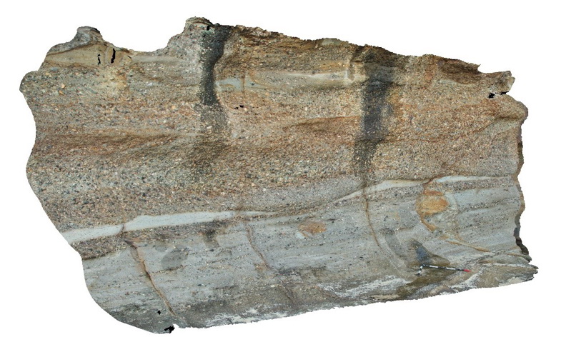
Bombo3 Map
 |
5 |
07/08/2015 9:39 a.m. |
3D |
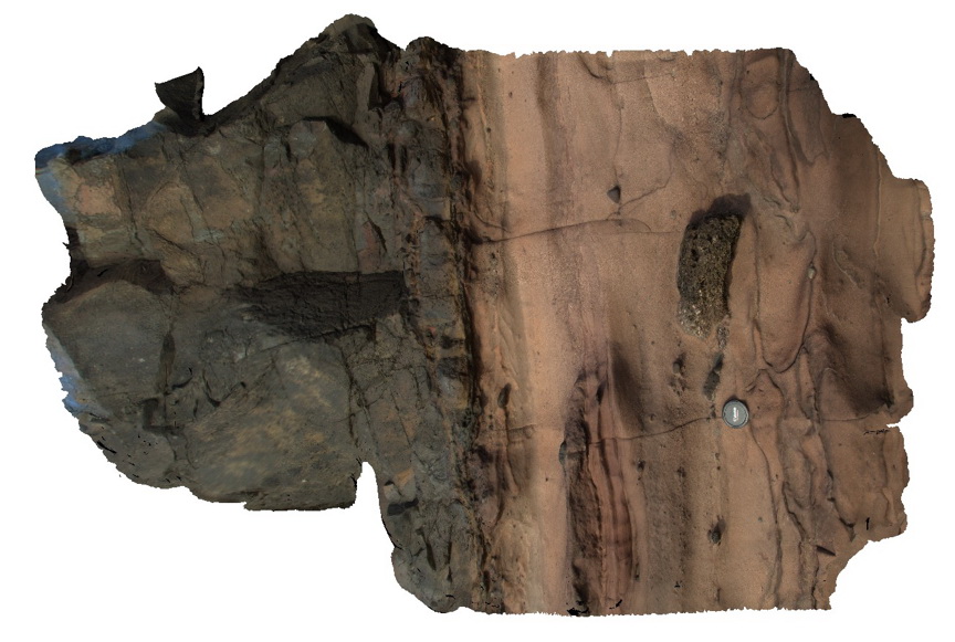
detail of contact shown in bombo2 model between Permian Bumbo Latite and underlying tuffaceous sandstone showing clasts of vesicular basalt up to 0.25m. Bombo, N.S.W. |
1.50 |
-34.65277000000 |
150.86362000000 |
3.000 |
latite, basalt, volcanics, tuff, igneous |
latite, tuff |
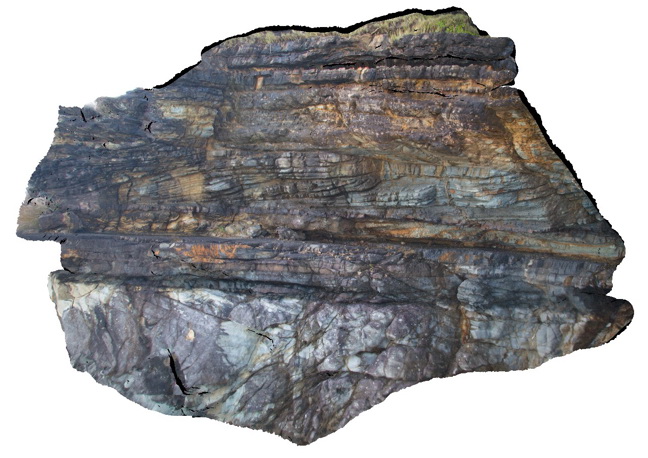
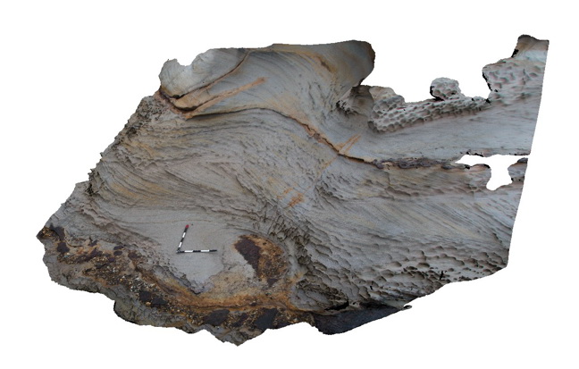
Bombo4 Map
 |
5 |
07/08/2015 9:40 a.m. |
3D |
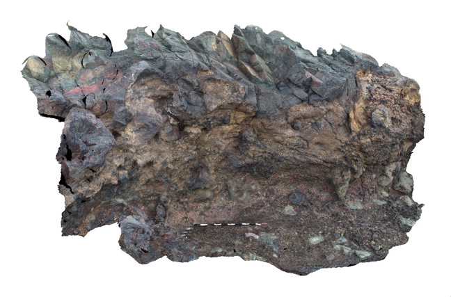
detail of irregular basal contact of the Permian Bumbo Latite with underlying volcanic breccia. Bombo, N.S.W. |
5.00 |
-34.65303000000 |
150.86308000000 |
2.000 |
latite, volcanic breccia, volcanics, breccia, igneous |
latite, breccia |
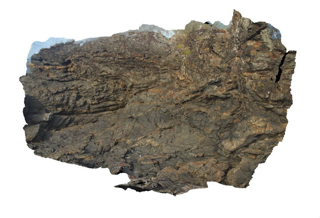
Bombo4 Map
|
5 |
07/08/2015 9:40 a.m. |
3D |
detail of irregular basal contact of the Permian Bumbo Latite with underlying volcanic breccia. Bombo, N.S.W. |
5.00 |
-34.65303000000 |
150.86308000000 |
2.000 |
latite, volcanic breccia, volcanics, breccia, igneous |
latite, breccia |
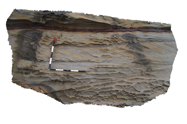
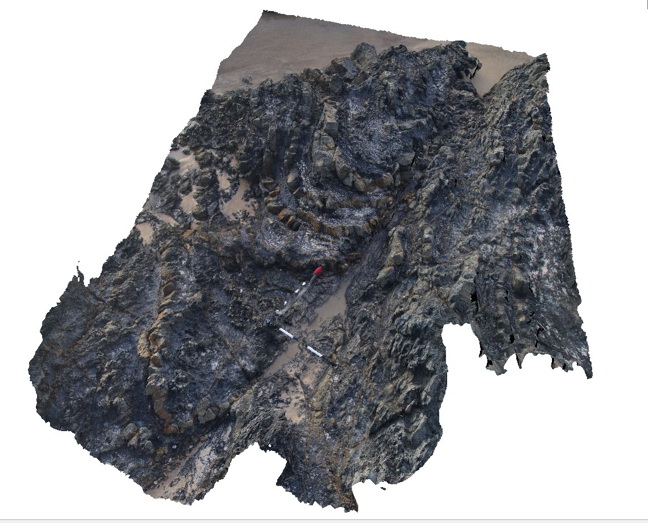
Bombo5 Map
 |
5 |
07/08/2015 9:41 a.m. |
3D |
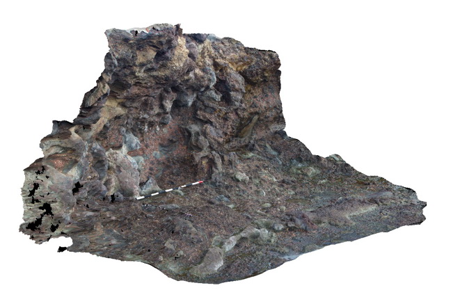
volcanic breccia with irregular 'tubes' of lava between clasts. Bombo, N.S.W. |
4.00 |
-34.65195000000 |
150.86299000000 |
2.000 |
volcanics, volcanic breccia, lava, igneous |
breccia |
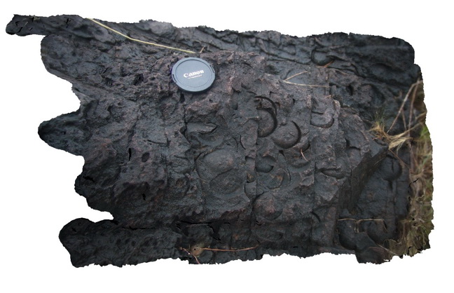
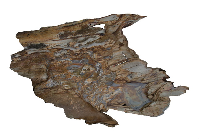
Bombo6 Map
 |
5 |
07/08/2015 9:41 a.m. |
3D |
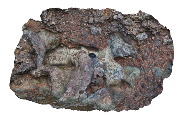
detail of lava 'tubes' within enclosing volcanic breccia. Bombo, N.S.W. |
1.50 |
-34.65195000000 |
150.86299000000 |
2.000 |
lava, latite, basalt, volcanic breccia, volcanics, igneous |
latite, Breccia |
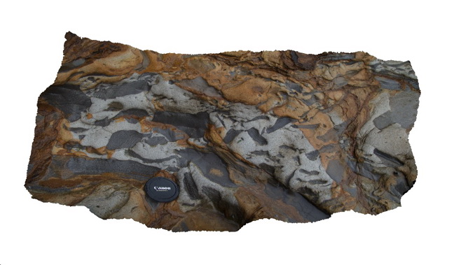
Bombo6 Map
|
5 |
07/08/2015 9:41 a.m. |
3D |
detail of lava 'tubes' within enclosing volcanic breccia. Bombo, N.S.W. |
1.50 |
-34.65195000000 |
150.86299000000 |
2.000 |
lava, latite, basalt, volcanic breccia, volcanics, igneous |
latite, Breccia |
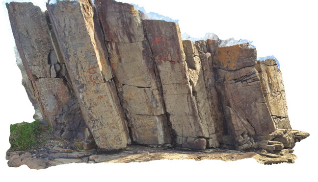
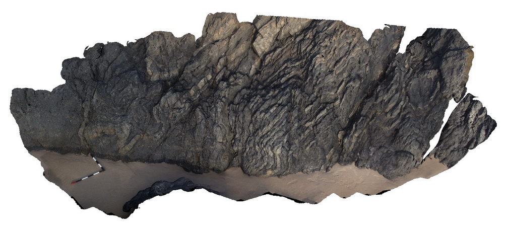
Bombo7 Map
 |
5 |
07/08/2015 9:42 a.m. |
3D |
Columnar jointed flow of Bombo Latite. Bombo, N.S.W. |
10.00 |
-34.65206000000 |
150.86278000000 |
7.000 |
basalt, latite, volcanics, columnar joints, igneous |
latite |
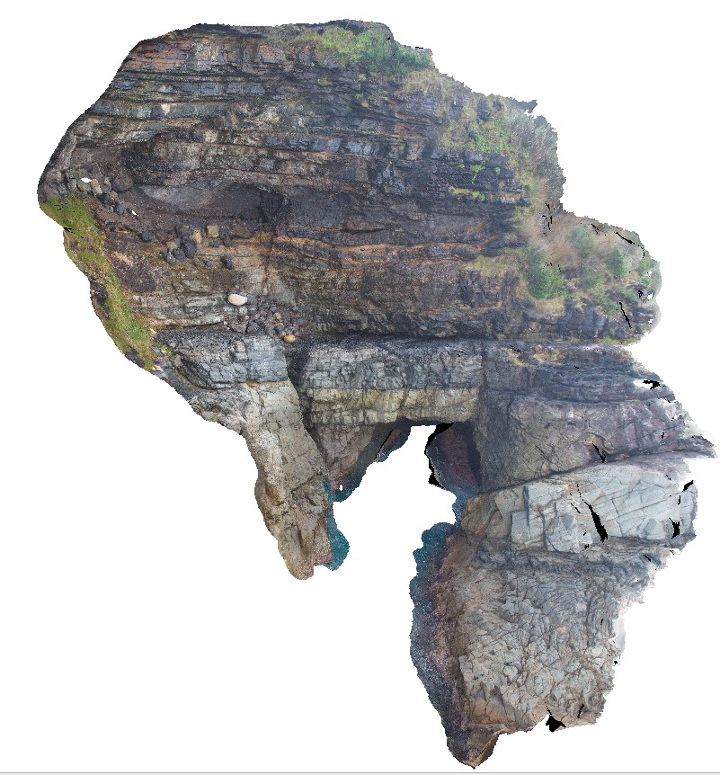
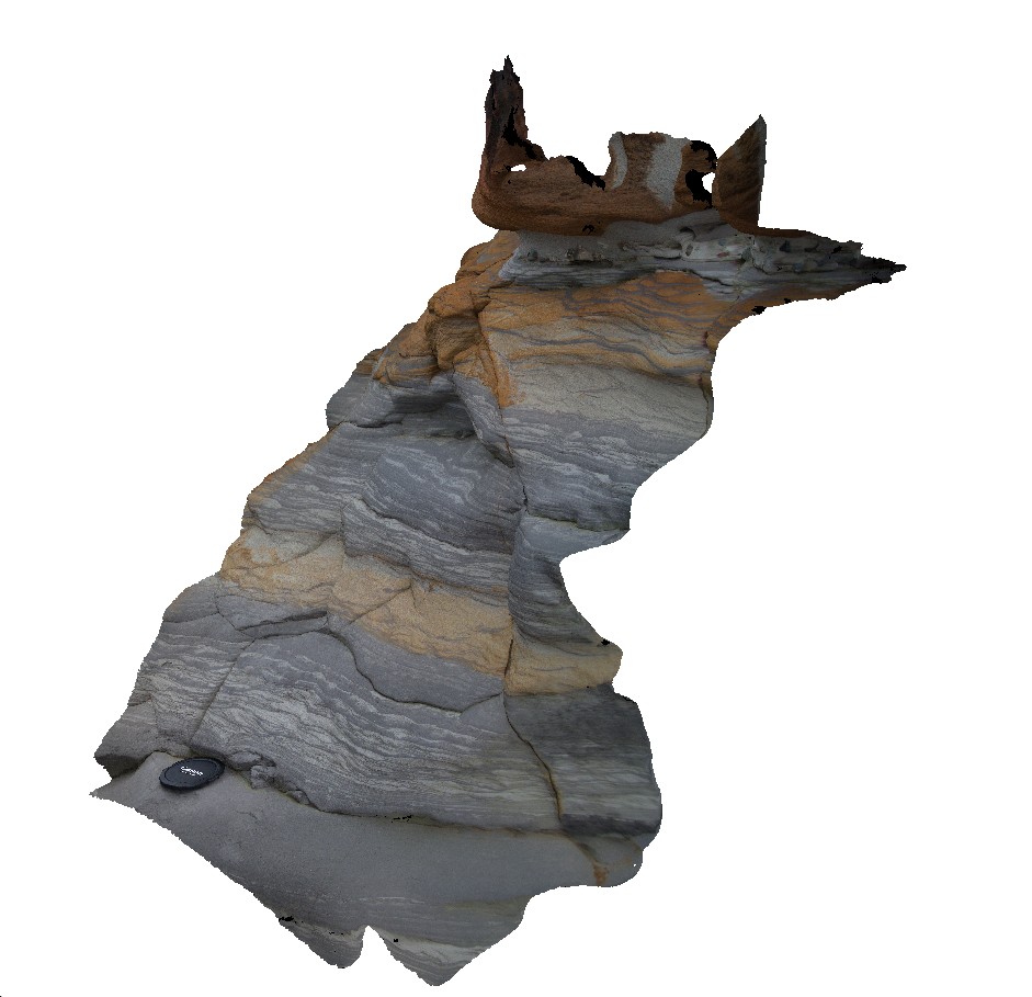
Booti1 Map
 |
5 |
07/08/2015 9:43 a.m. |
3D |
Dipping thickly bedded sandstone and minor siltstone of the Booti Booti Sandstone with a sea cave. Booti Booti, N.S.W. |
12.00 |
-32.31560000000 |
152.52878000000 |
5.000 |
sandstone, sea cave, fault, sedimentology, geomorphology |
sandstone |
Booti2 Map
 |
5 |
07/08/2015 9:44 a.m. |
3D |
Brachiopod valve casts infilled by calcite in Carboniferous sandstone of the Booti Booti Sandstone. Booti Booti, N.S.W. |
0.70 |
-32.31560000000 |
152.52880000000 |
5.000 |
sandstone, brachiopods, fossils, sedimentology, palaeontology |
sandstone |
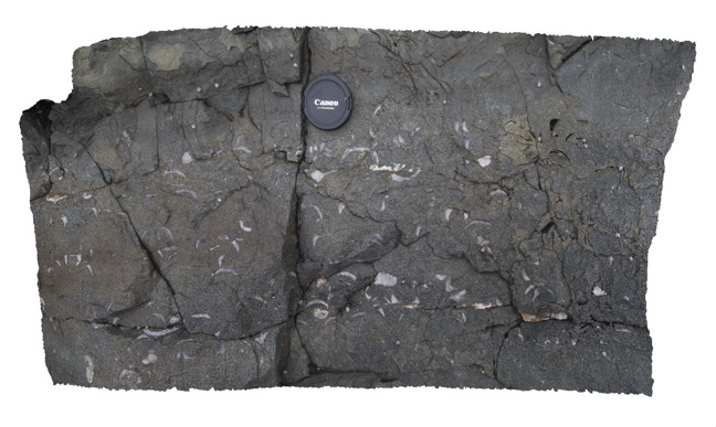
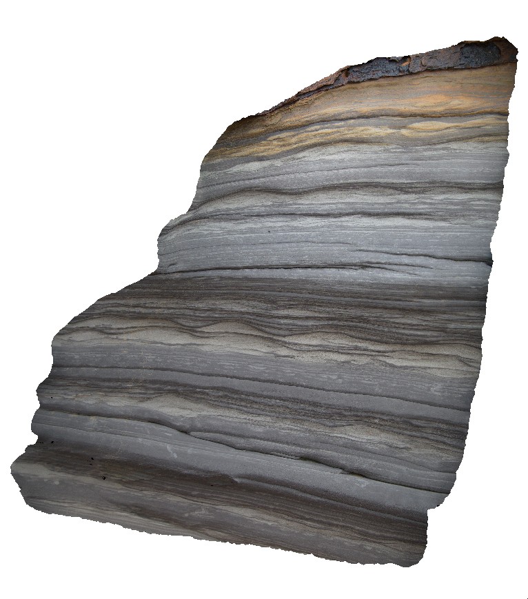
Booti3 Map
 |
5 |
07/08/2015 9:45 a.m. |
3D |
Cross bedding in thickly bedded sandstone layers of the Carboniferous Booti Booti Sandstone. Booti Booti, N.S.W. |
10.00 |
-32.31627000000 |
152.52956000000 |
8.000 |
sandstone, cross bedding, sedimentology |
sandstone |
Booti4 Map
 |
5 |
07/08/2015 9:46 a.m. |
3D |
Casts of brachiopod valves in medium to coarse grained sandstone of the Carboniferous Booti Booti Sandstone. Booti Booti, N.S.W. |
0.60 |
-32.31584000000 |
152.52887000000 |
8.000 |
sandstone, fossils, brachiopods, sedimentology, palaeontology |
sandstone |
Bouddi1 Map
 |
5 |
07/08/2015 9:54 a.m. |
3D |
Ripple cross laminations and bioturbation in sand/silt layers of the fluvial Triassic Narrabeen Group. Gerrin Point, N.S.W. |
1.00 |
-33.53091000000 |
151.37502000000 |
5.000 |
ripples, bioturbation, sandstone, siltstone, sedimentology, palaeontology |
sandstone, siltstone |
Bouddi1 Map
|
5 |
07/08/2015 9:54 a.m. |
3D |
Ripple cross laminations and bioturbation in sand/silt layers of the fluvial Triassic Narrabeen Group. Gerrin Point, N.S.W. |
1.00 |
-33.53091000000 |
151.37502000000 |
5.000 |
ripples, bioturbation, sandstone, siltstone, sedimentology, palaeontology |
sandstone, siltstone |
Bouddi2 Map
 |
5 |
07/08/2015 9:55 a.m. |
3D |
Ripples in thin sandstone layers interbedded with grey, bioturbated siltstone of the Triassic Narrabeen Group. No scale - ripples are ~0.15m half wavelength. Gerrin Point, N.S.W. |
1.00 |
-33.53093000000 |
151.37502000000 |
7.000 |
sandstone, siltstone, ripples, bioturbation, sedimentology |
sandstone, siltstone |
Bouddi2 Map
|
5 |
07/08/2015 9:55 a.m. |
3D |
Ripples in thin sandstone layers interbedded with grey, bioturbated siltstone of the Triassic Narrabeen Group. No scale - ripples are ~0.15m half wavelength. Gerrin Point, N.S.W. |
1.00 |
-33.53093000000 |
151.37502000000 |
7.000 |
sandstone, siltstone, ripples, bioturbation, sedimentology |
sandstone, siltstone |
Bouddi3 Map
 |
5 |
07/08/2015 9:57 a.m. |
3D |
Cross bedded medium to coarse grained quartz sandstone of the Triassic Narrabeen Group. Gerrin Point, N.S.W. |
5.00 |
-33.53099000000 |
151.37500000000 |
7.000 |
sandstone, cross bedded, sedimentology |
sandstone |
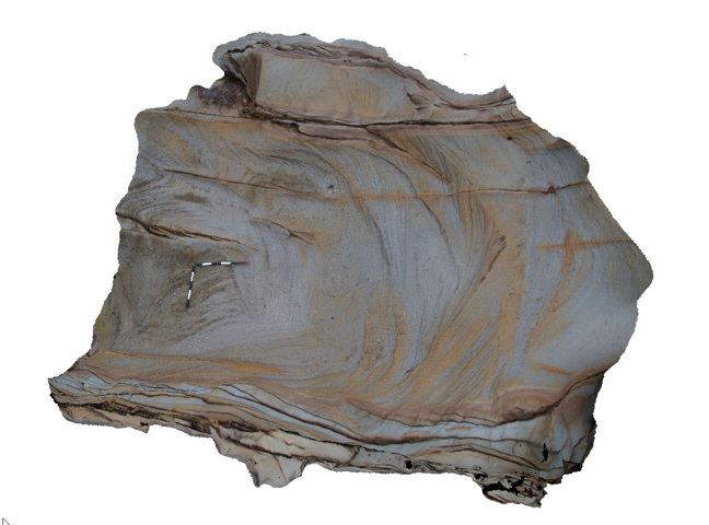
Bouddi4 Map
 |
5 |
07/08/2015 9:58 a.m. |
3D |
cross-bedded sandstone with honeycomb weathering and a pebble lag deposit - Triassic Narabeen Group. Gerrin Point, N.S.W. |
5.00 |
-33.53096000000 |
151.37479000000 |
4.000 |
sandstone, cross bedded, honeycomb weathering, pebble lag, sedimentology |
sandstone |
Bouddi5 Map
 |
5 |
07/08/2015 9:59 a.m. |
3D |
cross bedded sandstone with honeycomb weathering - Triassic Narrabeen Group. Gerrin Point, N.S.W. |
2.00 |
-33.53091000000 |
151.37473000000 |
5.000 |
sandstone, cross bedded, sedimentology, honeycomb weathering |
sandstone |
Bouddi6 Map
 |
5 |
07/08/2015 9:59 a.m. |
3D |
Intraformational breccia with mudstone rip-up clasts in sandstone of the Triassic Narrabeen Group. Gerrin Point, N.S.W. |
5.00 |
-33.53039000000 |
151.37462000000 |
1.000 |
sandstone, intraformational breccia, mudstone, rip-up clasts, sedimentology |
breccia |
Bouddi7 Map
 |
5 |
07/08/2015 10 a.m. |
3D |
Detail of intraformational breccia with mudstone rip-up clasts in a matrix of medium grained sandstone - Triassic Narrabeen Group. Gerrin Point, N.S.W. |
0.80 |
-33.53039000000 |
151.37462000000 |
1.000 |
sandstone, mudstone, rip-up clasts, intraformational breccia, sedimentology |
breccia |
Bungwahl1 Map
 |
5 |
06/20/2016 4:44 p.m. |
3D |
Reverse fault in sediments Carboniferous sediments of the Boolambayte Formation. Bungwahl, N.S.W. |
8.00 |
-32.38022000000 |
152.36542000000 |
-9999.000 |
sandstone, mudstone, reverse fault, structure |
sandstone |
Byron1 Map
 |
5 |
07/08/2015 10:18 a.m. |
3D |
folded and faulted fine grained, low grade metasediments of the Neranleigh-Fernvale Beds. Byron Bay, N.S.W. |
8.00 |
-28.63433000000 |
153.63599000000 |
1.000 |
metasediments, folds, faults, structure |
metasediments |
Byron2 Map
 |
5 |
07/08/2015 10:19 a.m. |
3D |
folded and faulted low-grade, fine grained metasediments of the Neranleigh-Fernvale Beds. Byron Bay, N.S.W. |
8.00 |
-28.63455000000 |
153.63579000000 |
1.000 |
metasediments, folds, faults, structure |
metasediments |
Byron3 Map
 |
5 |
07/08/2015 10:20 a.m. |
3D |
folded and faulted low-grade, fine grained metasediments of the Neranleigh-Fernvale Beds. Byron Bay, N.S.W. |
6.00 |
-28.63475000000 |
153.63560000000 |
1.000 |
metasediments, folds, faults, structure |
metasediments |
CavesBch1 Map
 |
5 |
07/08/2015 10:21 a.m. |
3D |
Fluvial sandstone and conglomerate of the Permian Boolaroo Formation. Caves Beach, N.S.W. |
8.00 |
-33.11150000000 |
151.64642000000 |
2.000 |
sandstone, conglomerate, fluvial, sedimentology |
sandstone, conglomerate |