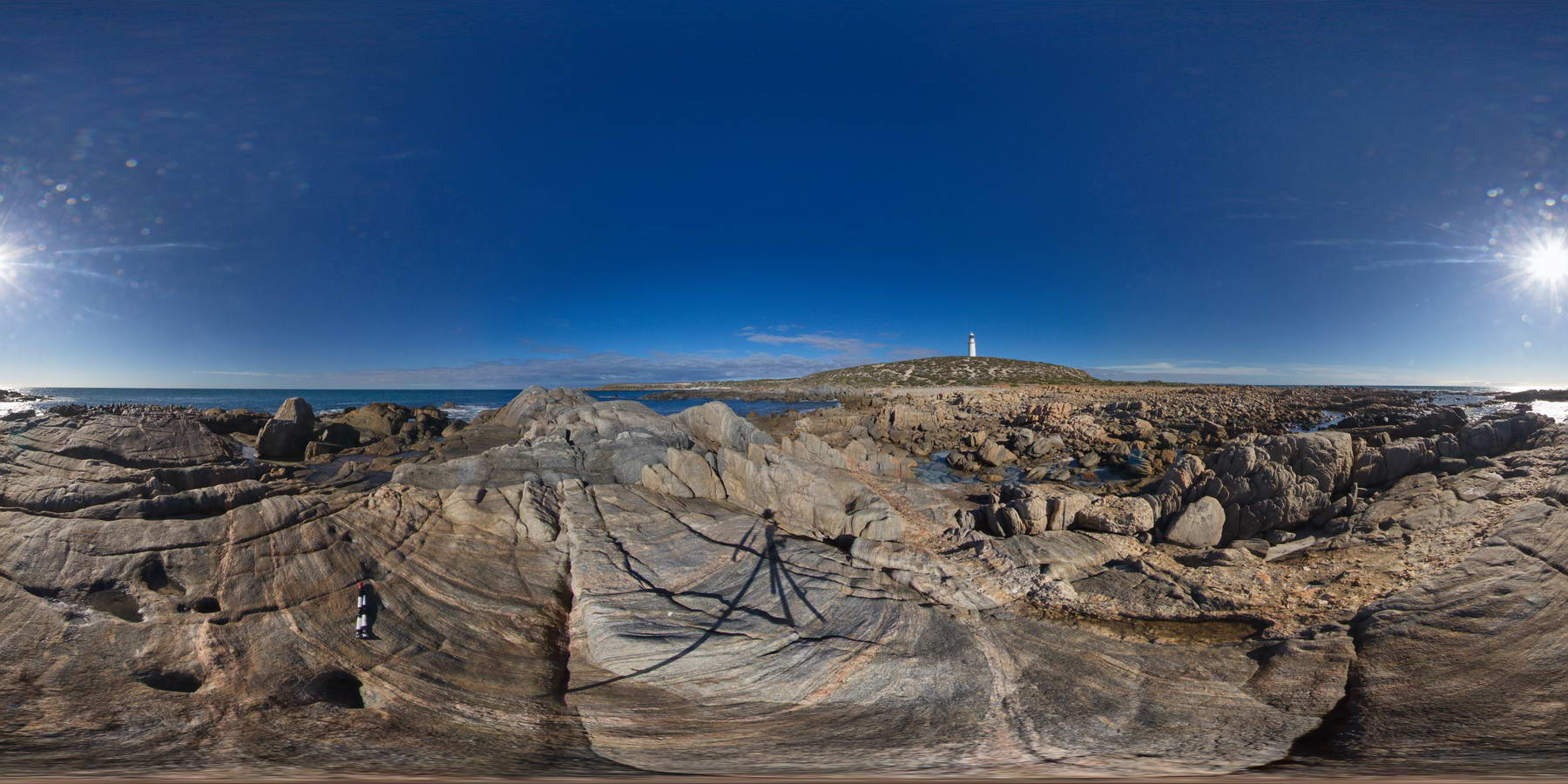
CornyFSP1 Map
 |
0 |
01/27/2016 11:33 a.m. |
FSP |
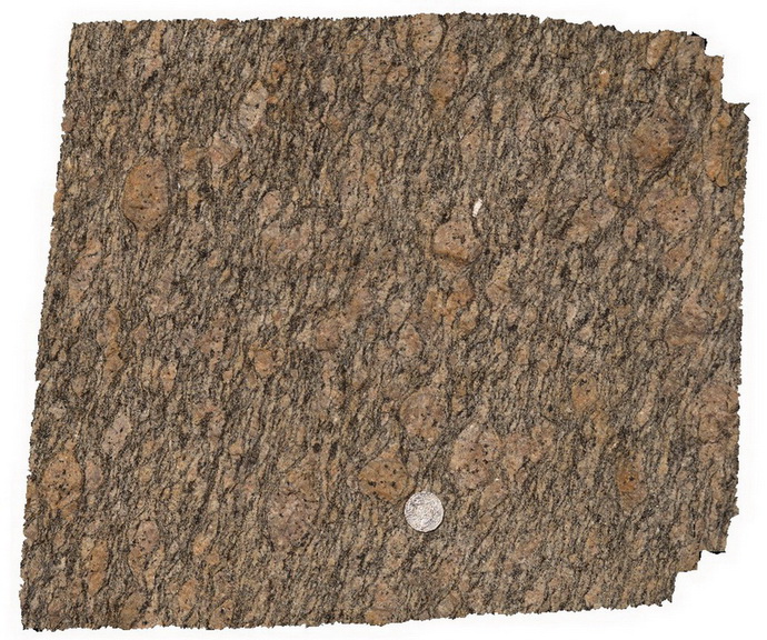
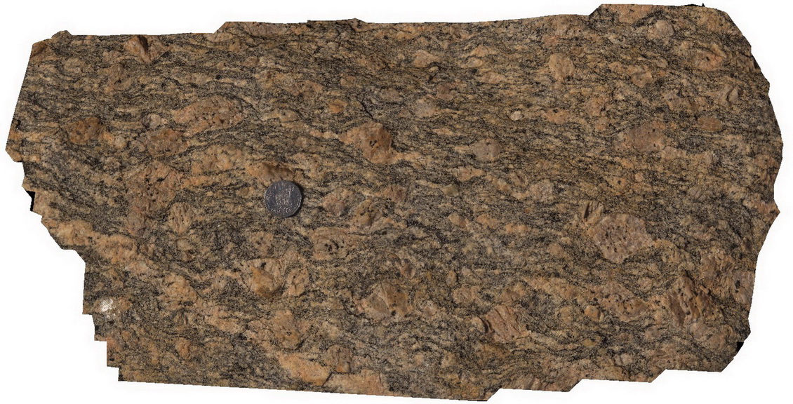
shoreline outcrop showing banded gneiss intruded by pegmatitic dyke. Point Corny. S.A. |
2000.00 |
-34.89556000000 |
137.00983000000 |
-9999.000 |
pegmatitic dyke, intrusive contact, gneiss, metamorphic |
gneiss, pegmatite |
CornyFSP1 Map
|
0 |
01/27/2016 11:33 a.m. |
FSP |
shoreline outcrop showing banded gneiss intruded by pegmatitic dyke. Point Corny. S.A. |
2000.00 |
-34.89556000000 |
137.00983000000 |
-9999.000 |
pegmatitic dyke, intrusive contact, gneiss, metamorphic |
gneiss, pegmatite |
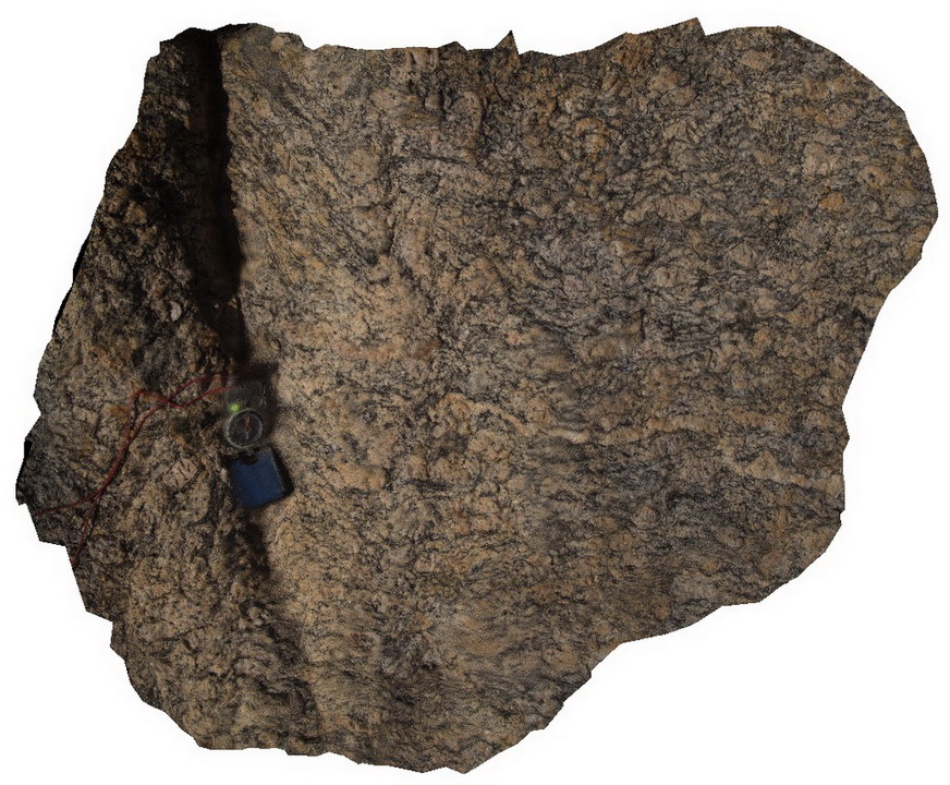
Corny5 Map
 |
0 |
11/17/2015 12:23 p.m. |
3D |
view of the fabric of folded Augen gneiss. Point Corny. S.A. |
0.50 |
-34.92128000000 |
137.01132000000 |
-9999.000 |
augen gneiss, metamorphic |
augen gneiss |
Corny5 Map
|
0 |
11/17/2015 12:23 p.m. |
3D |
view of the fabric of folded Augen gneiss. Point Corny. S.A. |
0.50 |
-34.92128000000 |
137.01132000000 |
-9999.000 |
augen gneiss, metamorphic |
augen gneiss |
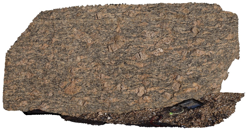
Corny6 Map
 |
0 |
02/12/2016 11:37 a.m. |
3D |
rotated augens in augen gneiss. Point Corny. S.A. |
0.40 |
-34.92134000000 |
137.01105000000 |
-9999.000 |
augen gneiss, augen |
augen gneiss |
Corny6 Map
|
0 |
02/12/2016 11:37 a.m. |
3D |
rotated augens in augen gneiss. Point Corny. S.A. |
0.40 |
-34.92134000000 |
137.01105000000 |
-9999.000 |
augen gneiss, augen |
augen gneiss |
Corny7 Map
 |
0 |
11/17/2015 12:24 p.m. |
3D |
detail of rotated augens in augen gneiss. Point Corny. S.A. |
0.15 |
-34.92134000000 |
137.01105000000 |
-9999.000 |
rotated augen, gneiss |
augen gneiss |
Corny7 Map
|
0 |
11/17/2015 12:24 p.m. |
3D |
detail of rotated augens in augen gneiss. Point Corny. S.A. |
0.15 |
-34.92134000000 |
137.01105000000 |
-9999.000 |
rotated augen, gneiss |
augen gneiss |
Corny8 Map
 |
0 |
11/17/2015 12:24 p.m. |
3D |
detail of augen in augen gneiss. Point Corny. S.A. |
0.30 |
-34.92155000000 |
137.01103000000 |
-9999.000 |
augen gneiss, metamorphic |
augen gneiss |
Corny8 Map
|
0 |
11/17/2015 12:24 p.m. |
3D |
detail of augen in augen gneiss. Point Corny. S.A. |
0.30 |
-34.92155000000 |
137.01103000000 |
-9999.000 |
augen gneiss, metamorphic |
augen gneiss |
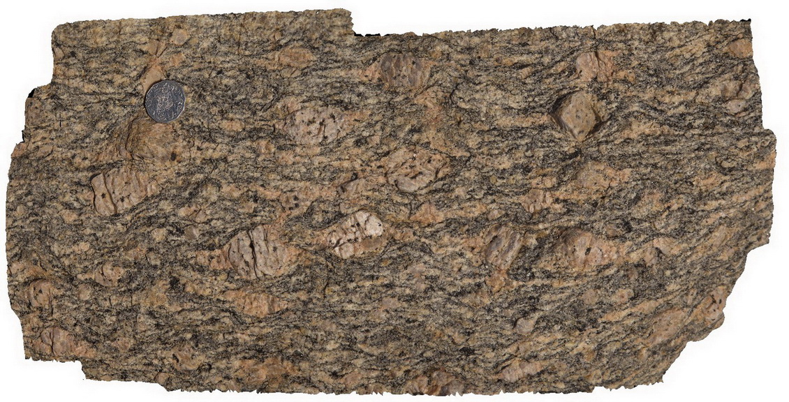
Corny9 Map
 |
0 |
11/17/2015 12:25 p.m. |
3D |
detail of feldspar augens in gneiss with wings. Point Corny. S.A. |
0.30 |
-34.92136000000 |
137.01102000000 |
-9999.000 |
augen, gneiss, structure |
augen gneiss |
Corny9 Map
|
0 |
11/17/2015 12:25 p.m. |
3D |
detail of feldspar augens in gneiss with wings. Point Corny. S.A. |
0.30 |
-34.92136000000 |
137.01102000000 |
-9999.000 |
augen, gneiss, structure |
augen gneiss |
Corny9 Map
|
0 |
11/17/2015 12:25 p.m. |
3D |
detail of feldspar augens in gneiss with wings. Point Corny. S.A. |
0.30 |
-34.92136000000 |
137.01102000000 |
-9999.000 |
augen, gneiss, structure |
augen gneiss |
Pennington1 Map
 |
0 |
10/20/2015 3:31 p.m. |
3D |
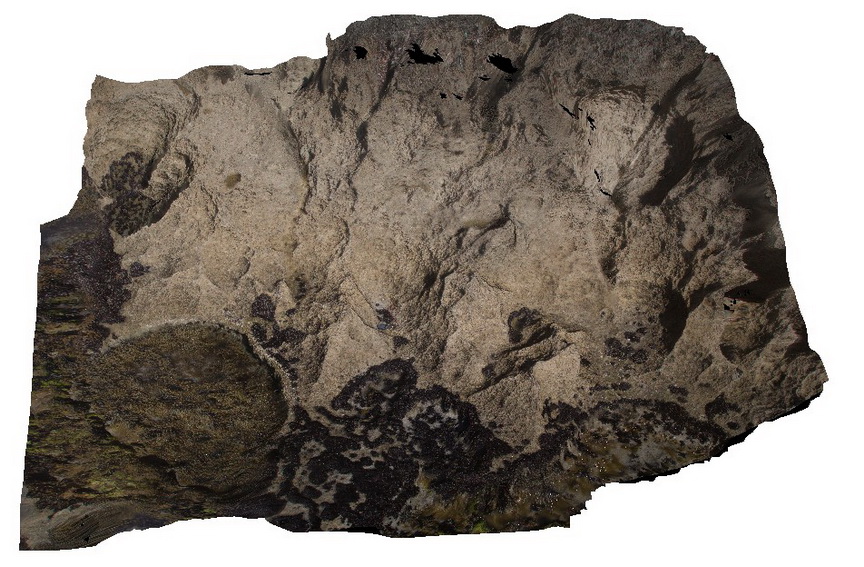
detail of flat-lying calcarenite, lower Bridgewater Formation. Pennington. Kangaroo Island. |
2.00 |
-35.85672000000 |
137.73549000000 |
-9999.000 |
calcarenite |
calcarenite |
PenningtonUAV1 Map
 |
0 |
10/20/2015 3:34 p.m. |
UAV |
aerial view of calcarenite cliff at Pennington, Kangaroo Island. |
100.00 |
-35.85815100000 |
137.73509800000 |
-9999.000 |
calcarenite, cliff |
calcarenite |
PenningtonUAV1 Map
|
0 |
10/20/2015 3:34 p.m. |
UAV |
aerial view of calcarenite cliff at Pennington, Kangaroo Island. |
100.00 |
-35.85815100000 |
137.73509800000 |
-9999.000 |
calcarenite, cliff |
calcarenite |
Pennington2 Map
 |
0 |
10/20/2015 3:32 p.m. |
3D |
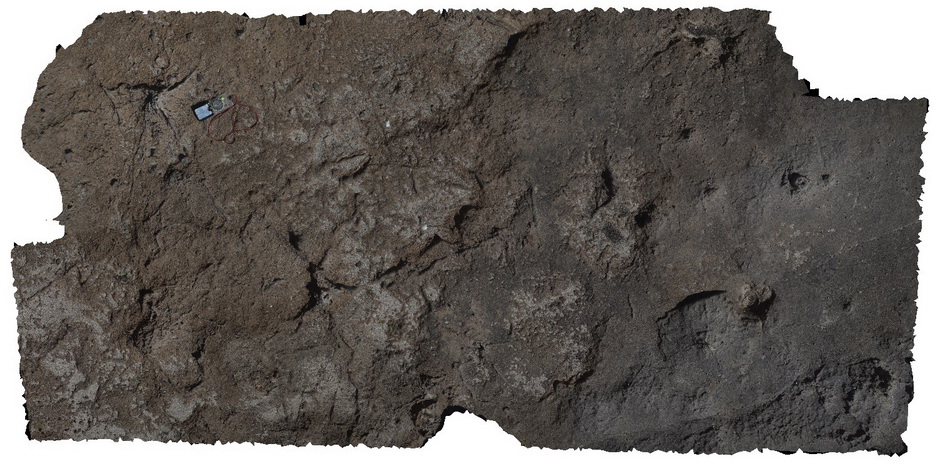
tree and root casts in calcareous sandstone. Penninton, Kangaroo Island. |
3.00 |
-35.85736000000 |
137.73445000000 |
-9999.000 |
tree cast, root cast, calcareous sandstone |
sandstone |
Pennington2 Map
|
0 |
10/20/2015 3:32 p.m. |
3D |
tree and root casts in calcareous sandstone. Penninton, Kangaroo Island. |
3.00 |
-35.85736000000 |
137.73445000000 |
-9999.000 |
tree cast, root cast, calcareous sandstone |
sandstone |
Pennington2 Map
|
0 |
10/20/2015 3:32 p.m. |
3D |
tree and root casts in calcareous sandstone. Penninton, Kangaroo Island. |
3.00 |
-35.85736000000 |
137.73445000000 |
-9999.000 |
tree cast, root cast, calcareous sandstone |
sandstone |
Pennington3 Map
 |
0 |
10/20/2015 3:32 p.m. |
3D |
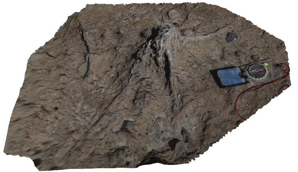
detail of stump cast in calcareous sandstones. Pennington, Kangaroo Island. |
0.25 |
-35.85736000000 |
137.73445000000 |
-9999.000 |
calcareous sandstones, cast |
sandstone |
Pennington3 Map
|
0 |
10/20/2015 3:32 p.m. |
3D |
detail of stump cast in calcareous sandstones. Pennington, Kangaroo Island. |
0.25 |
-35.85736000000 |
137.73445000000 |
-9999.000 |
calcareous sandstones, cast |
sandstone |
PenningtonUAV2 Map
 |
0 |
10/20/2015 3:34 p.m. |
UAV |
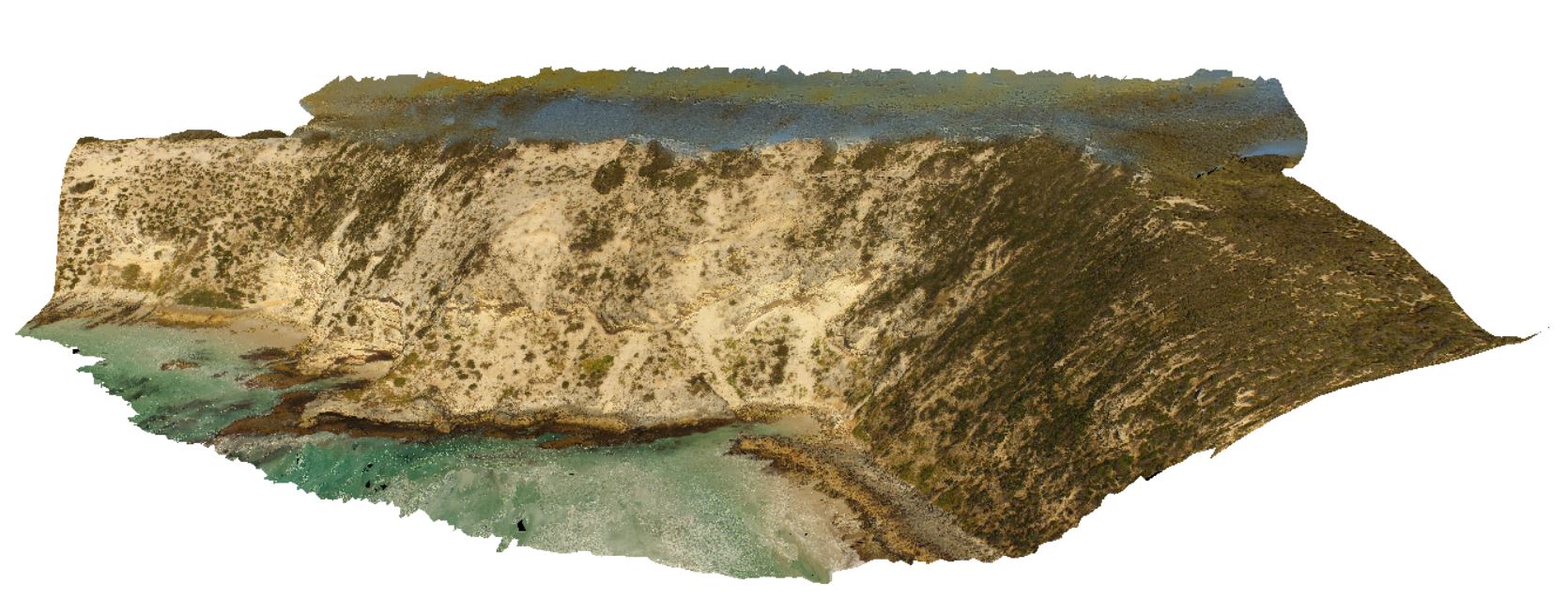
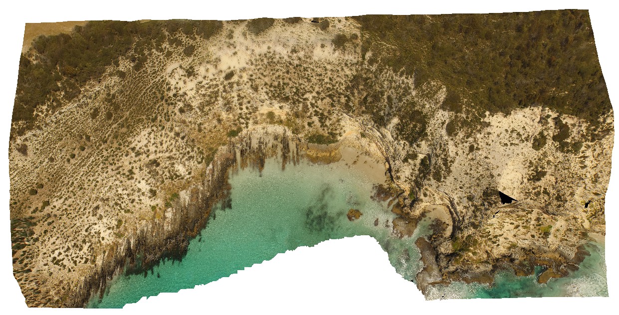
aerial view showing the Petrel Cove Formation of the Kanmantoo Trough overlain by the younger Bridgewater Formation. Pennington Bay, Kangaroo Island. |
500.00 |
-35.85948000000 |
137.73521600000 |
-9999.000 |
unconformity, sandstone, calcareous sandstone |
sandstone, sandstone |
PenningtonUAV2 Map
|
0 |
10/20/2015 3:34 p.m. |
UAV |
aerial view showing the Petrel Cove Formation of the Kanmantoo Trough overlain by the younger Bridgewater Formation. Pennington Bay, Kangaroo Island. |
500.00 |
-35.85948000000 |
137.73521600000 |
-9999.000 |
unconformity, sandstone, calcareous sandstone |
sandstone, sandstone |
Pennington4 Map
 |
0 |
10/20/2015 3:33 p.m. |
3D |
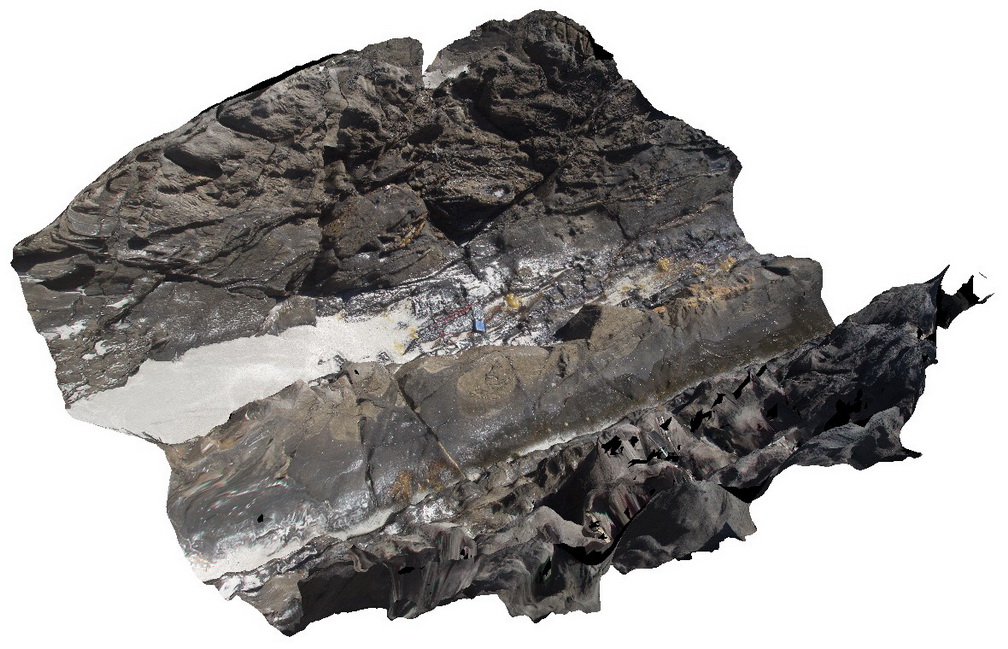
detail of Petrel Cove Formation meta-sediments, showing bedded, ripup clasts? And other sedimentary features. Pennington Bay, Kangaroo Island. |
1.50 |
-35.86062000000 |
137.73601000000 |
-9999.000 |
bedding, sedimentology |
sandstone |